Lunéville geodata
Lunéville (Grand Est) is a seat of a third-order administrative division; located in France in Europe/Paris (GMT+2) time zone. With population of 21,582 people, there are 415 cities with bigger population in this country. Compared to other cities in France, 70.7% of cities are located further ↓South; 91.7% of cities are located further ←West and 72.2% of cities have lower elevation than Lunéville. Note1
Administrative division(s):
- Level 1: Grand Est
- Level 2: Meurthe-et-Moselle
- Level 3: Arrondissement de Lunéville
- Level 4: Lunéville


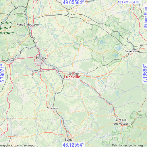
Lunéville GPS coordinates[2]
48° 35' 33.828" North, 6° 29' 37.788" East
| Map corner | latitude | longitude |
|---|---|---|
| Upper-left | 49.05564°, | 5.79071° |
| Center: | 48.59273°, | 6.49383° |
| Lower-right: | 48.12554°, | 7.19696° |
| Map W x H: | 103.4×103.4 km | = 64.2×64.2mi |
| max Lat: | 51.07786° ⇑29.3% North |
| Lunéville: | 48.59273° |
| min Lat: | ⇓70.7% South 41.3874° |
| min Long | Lunéville | max Long |
| -5.08615° | 6.49383° | 9.52242° |
| W 91.7%⇐ | ⇒8.3% E |
Elevation
Elevation of Lunéville is 231 m = 758 ft, and this is 37.3 m = 122 ft above average elevation for this country.
| Max E: |
2333 m = 7654 ft | 27.8% |
| Lunéville | 231 m 758 ft | |
| Avg. | 193.7 m = 635 ft | |
Min E: |
-1 m = -3 ft | 72.2% |
See also: France elevation on elevation.city.
Geographical zone
Lunéville is located in North temperate zone (between Tropic of Cancer and the Arctic Circle). Distance of this North polar circle is 1998.2 km =1241.6 mi to North.| Distance of | km | miles | from Lunéville |
|---|---|---|---|
| North Pole | 4604.1 | 2860.9 | to North |
| Arctic Circle | 1998.2 | 1241.6 | to North |
| Tropic Cancer | 2797.1 | 1738 | to South |
| Equator | 5403 | 3357.3 | to South |


Nearby cities:
15 places around Lunéville: (largest is in red/bold)
• Chanteheux
2.5 km =1.6 mi,  78°
78°
• Croismare
5.7 km =3.5 mi, 83°
• Crévic
8.4 km =5.2 mi,  308°
308°
• Damelevières
8.9 km =5.5 mi,  245°
245°
• Dombasle-sur-Meurthe
10.6 km =6.6 mi,  285°
285°
• Einville-au-Jard
7 km =4.3 mi,  354°
354°
• Gerbéviller
10.8 km =6.7 mi,  173°
173°
• Hériménil
2.7 km =1.7 mi,  176°
176°
• Jolivet
1.7 km =1.1 mi,  25°
25°
• Marainviller
7.9 km =4.9 mi,  93°
93°
• Mont-sur-Meurthe
5.7 km =3.5 mi,  222°
222°
• Rehainviller
3.7 km =2.3 mi,  207°
207°
• Rosières-aux-Salines
11.9 km =7.4 mi,  270°
270°
• Saint-Clément
10.6 km =6.6 mi,  130°
130°
• Sommerviller
9.7 km =6 mi,  296°
296°
Sources, notices
• [Note1] Compared only with cities in France existing in our database
• [Src1] Map data: © OpenStreetMap contributors (CC-BY-SA)
• [Src2] Other city data from geonames.org with taken over terms of usage.
• [Src3] Geographical zone / Annual Mean Temperature by Robert A. Rohde @ Wikipedia
