Montseveroux geodata
Montseveroux (Auvergne-Rhône-Alpes) is a populated place; located in France in Europe/Paris (GMT+2) time zone. With population of 846 people, there are 10125 cities with bigger population in this country. Compared to other cities in France, 74.9% of cities are located further ↑North; 77.4% of cities are located further ←West and 88.5% of cities have lower elevation than Montseveroux. Note1
Administrative division(s):
- Level 1: Auvergne-Rhône-Alpes
- Level 2: Département de l'Isère
- Level 3: Arrondissement de Vienne
- Level 4: Montseveroux


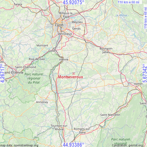
Montseveroux GPS coordinates[2]
45° 25' 46.056" North, 4° 58' 13.044" East
| Map corner | latitude | longitude |
|---|---|---|
| Upper-left | 45.92075°, | 4.26717° |
| Center: | 45.42946°, | 4.97029° |
| Lower-right: | 44.93386°, | 5.67342° |
| Map W x H: | 109.7×109.7 km | = 68.2×68.2mi |
| max Lat: | 51.07786° ⇑74.9% North |
| Montseveroux: | 45.42946° |
| min Lat: | ⇓25.1% South 41.3874° |
| min Long | Montseveroux | max Long |
| -5.08615° | 4.97029° | 9.52242° |
| W 77.4%⇐ | ⇒22.6% E |
Elevation
Elevation of Montseveroux is 396 m = 1299 ft, and this is 202.3 m = 664 ft above average elevation for this country.
| Max E: |
2333 m = 7654 ft | 11.5% |
| Montseveroux | 396 m 1299 ft | |
| Avg. | 193.7 m = 635 ft | |
Min E: |
-1 m = -3 ft | 88.5% |
See also: France elevation on elevation.city.
Geographical zone
Montseveroux is located in North temperate zone (between Tropic of Cancer and the Arctic Circle). Distance of this North polar circle is 2349.9 km =1460.2 mi to North.| Distance of | km | miles | from Montseveroux |
|---|---|---|---|
| North Pole | 4955.8 | 3079.4 | to North |
| Arctic Circle | 2349.9 | 1460.2 | to North |
| Tropic Cancer | 2445.4 | 1519.5 | to South |
| Equator | 5051.3 | 3138.7 | to South |


Nearby cities:
15 places around Montseveroux: (largest is in red/bold)
• Bellegarde-Poussieu
6.1 km =3.8 mi,  193°
193°
• Cour-et-Buis
3 km =1.9 mi,  65°
65°
• Eyzin-Pinet
5.4 km =3.4 mi,  24°
24°
• Jardin
8.9 km =5.5 mi,  327°
327°
• La Chapelle-de-Surieu
6.4 km =4 mi,  229°
229°
• Les Côtes-d'Arey
8.6 km =5.3 mi,  290°
290°
• Meyssiez
8 km =5 mi,  57°
57°
• Moissieu-sur-Dolon
5 km =3.1 mi,  162°
162°
• Monsteroux-Milieu
1.9 km =1.2 mi,  270°
270°
• Pact
8.8 km =5.5 mi,  170°
170°
• Pisieu
8.5 km =5.3 mi,  123°
123°
• Primarette
5.6 km =3.5 mi, 124°
• Revel
7.2 km =4.5 mi,  136°
136°
• Saint-Sorlin-de-Vienne
5 km =3.1 mi, 325°
• Vernioz
6.8 km =4.2 mi, 267°
Sources, notices
• [Note1] Compared only with cities in France existing in our database
• [Src1] Map data: © OpenStreetMap contributors (CC-BY-SA)
• [Src2] Other city data from geonames.org with taken over terms of usage.
• [Src3] Geographical zone / Annual Mean Temperature by Robert A. Rohde @ Wikipedia
