La Chapelle-de-Surieu geodata
La Chapelle-de-Surieu (Auvergne-Rhône-Alpes) is a populated place; located in France in Europe/Paris (GMT+2) time zone. With population of 517 people, there are 14885 cities with bigger population in this country. Compared to other cities in France, 75.4% of cities are located further ↑North; 76.6% of cities are located further ←West and 81.5% of cities have lower elevation than La Chapelle-de-Surieu. Note1
Administrative division(s):
- Level 1: Auvergne-Rhône-Alpes
- Level 2: Département de l'Isère
- Level 3: Arrondissement de Vienne
- Level 4: La Chapelle-de-Surieu
Current local time in La Chapelle-de-Surieu:
03:57 PM, SaturdayDifference from your time zone: hours


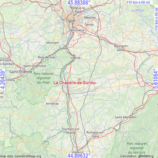
La Chapelle-de-Surieu GPS coordinates[2]
45° 23' 32.1" North, 4° 54' 27.036" East
| Map corner | latitude | longitude |
|---|---|---|
| Upper-left | 45.88386°, | 4.20439° |
| Center: | 45.39225°, | 4.90751° |
| Lower-right: | 44.89632°, | 5.61064° |
| Map W x H: | 109.8×109.8 km | = 68.2×68.2mi |
| max Lat: | 51.07786° ⇑75.4% North |
| La Chapelle-de-Surieu: | 45.39225° |
| min Lat: | ⇓24.6% South 41.3874° |
| min Long | La Chapelle-de- | max Long |
| -5.08615° | 4.90751° | 9.52242° |
| W 76.6%⇐ | ⇒23.4% E |
Elevation
Elevation of La Chapelle-de-Surieu is 305 m = 1001 ft, and this is 111.3 m = 365 ft above average elevation for this country.
| Max E: |
2333 m = 7654 ft | 18.5% |
| La Chapelle-de-Surieu | 305 m 1001 ft | |
| Avg. | 193.7 m = 635 ft | |
Min E: |
-1 m = -3 ft | 81.5% |
See also: France elevation on elevation.city.
Geographical zone
La Chapelle-de-Surieu is located in North temperate zone (between Tropic of Cancer and the Arctic Circle). Distance of this North polar circle is 2354 km =1462.7 mi to North.| Distance of | km | miles | from La Chapelle-de-Surieu |
|---|---|---|---|
| North Pole | 4959.9 | 3081.9 | to North |
| Arctic Circle | 2354 | 1462.7 | to North |
| Tropic Cancer | 2441.2 | 1516.9 | to South |
| Equator | 5047.1 | 3136.1 | to South |


Nearby cities:
15 places around La Chapelle-de-Surieu: (largest is in red/bold)
• Agnin
7.2 km =4.5 mi,  216°
216°
• Anjou
5.2 km =3.2 mi,  200°
200°
• Assieu
4 km =2.5 mi,  290°
290°
• Auberives-sur-Varèze
7.6 km =4.7 mi, 294°
• Bellegarde-Poussieu
4 km =2.5 mi,  117°
117°
• Bougé-Chambalud
6.9 km =4.3 mi,  185°
185°
• Cheyssieu
6.7 km =4.2 mi,  306°
306°
• Jarcieu
7.1 km =4.4 mi,  156°
156°
• Moissieu-sur-Dolon
6.5 km =4 mi,  95°
95°
• Monsteroux-Milieu
5.1 km =3.2 mi,  35°
35°
• Montseveroux
6.4 km =4 mi,  49°
49°
• Roussillon
7.5 km =4.7 mi,  254°
254°
• Sonnay
3.8 km =2.4 mi,  183°
183°
• Vernioz
4.3 km =2.7 mi,  333°
333°
• Ville-sous-Anjou
4.9 km =3 mi,  243°
243°
Sources, notices
• [Note1] Compared only with cities in France existing in our database
• [Src1] Map data: © OpenStreetMap contributors (CC-BY-SA)
• [Src2] Other city data from geonames.org with taken over terms of usage.
• [Src3] Geographical zone / Annual Mean Temperature by Robert A. Rohde @ Wikipedia
