Revel geodata
Revel (Auvergne-Rhône-Alpes) is a populated place; located in France in Europe/Paris (GMT+2) time zone. With population of 919 people, there are 9496 cities with bigger population in this country. Compared to other cities in France, 75.5% of cities are located further ↑North; 78% of cities are located further ←West and 85% of cities have lower elevation than Revel. Note1
Administrative division(s):
- Level 1: Auvergne-Rhône-Alpes
- Level 2: Département de l'Isère
- Level 3: Arrondissement de Vienne
- Level 4: Revel-Tourdan


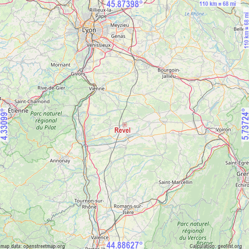
Revel GPS coordinates[2]
45° 22' 56.208" North, 5° 2' 2.832" East
| Map corner | latitude | longitude |
|---|---|---|
| Upper-left | 45.87398°, | 4.33099° |
| Center: | 45.38228°, | 5.03412° |
| Lower-right: | 44.88627°, | 5.73724° |
| Map W x H: | 109.8×109.8 km | = 68.2×68.2mi |
| max Lat: | 51.07786° ⇑75.5% North |
| Revel: | 45.38228° |
| min Lat: | ⇓24.5% South 41.3874° |
| min Long | Revel | max Long |
| -5.08615° | 5.03412° | 9.52242° |
| W 78%⇐ | ⇒22% E |
Elevation
Elevation of Revel is 346 m = 1135 ft, and this is 152.3 m = 500 ft above average elevation for this country.
| Max E: |
2333 m = 7654 ft | 15% |
| Revel | 346 m 1135 ft | |
| Avg. | 193.7 m = 635 ft | |
Min E: |
-1 m = -3 ft | 85% |
See also: France elevation on elevation.city.
Geographical zone
Revel is located in North temperate zone (between Tropic of Cancer and the Arctic Circle). Distance of this North polar circle is 2355.1 km =1463.4 mi to North.| Distance of | km | miles | from Revel |
|---|---|---|---|
| North Pole | 4961 | 3082.6 | to North |
| Arctic Circle | 2355.1 | 1463.4 | to North |
| Tropic Cancer | 2440.1 | 1516.2 | to South |
| Equator | 5046 | 3135.4 | to South |


Nearby cities:
15 places around Revel: (largest is in red/bold)
• Beaurepaire
5.2 km =3.2 mi,  167°
167°
• Bellegarde-Poussieu
6.4 km =4 mi,  263°
263°
• Cour-et-Buis
6.9 km =4.3 mi,  340°
340°
• Jarcieu
8.8 km =5.5 mi,  232°
232°
• Lapeyrouse-Mornay
7.2 km =4.5 mi,  204°
204°
• Manthes
8.8 km =5.5 mi,  191°
191°
• Marcollin
9.3 km =5.8 mi,  156°
156°
• Moissieu-sur-Dolon
3.5 km =2.2 mi,  277°
277°
• Monsteroux-Milieu
8.7 km =5.4 mi,  307°
307°
• Montseveroux
7.2 km =4.5 mi,  316°
316°
• Pact
4.9 km =3 mi, 225°
• Pajay
8.2 km =5.1 mi,  105°
105°
• Pisieu
2.2 km =1.4 mi,  75°
75°
• Pommier-de-Beaurepaire
6.8 km =4.2 mi,  74°
74°
• Primarette
2.1 km =1.3 mi,  348°
348°
Sources, notices
• [Note1] Compared only with cities in France existing in our database
• [Src1] Map data: © OpenStreetMap contributors (CC-BY-SA)
• [Src2] Other city data from geonames.org with taken over terms of usage.
• [Src3] Geographical zone / Annual Mean Temperature by Robert A. Rohde @ Wikipedia
