Saint-Georges-des-Groseillers geodata
Saint-Georges-des-Groseillers (Normandy) is a populated place; located in France in Europe/Paris (GMT+2) time zone. With population of 3,357 people, there are 2904 cities with bigger population in this country. Compared to other cities in France, 74.8% of cities are located further ↓South; 84.1% of cities are located further →East and 70.6% of cities have lower elevation than Saint-Georges-des-Groseillers. Note1
Administrative division(s):
- Level 1: Normandy
- Level 2: Département de l'Orne
- Level 3: Argentan
- Level 4: Saint-Georges-des-Groseillers
Current local time in Saint-Georges-des-Groseillers:
07:39 PM, SaturdayDifference from your time zone: hours


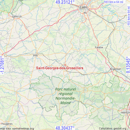
Saint-Georges-des-Groseillers GPS coordinates[2]
48° 46' 11.748" North, 0° 34' 3.648" West
| Map corner | latitude | longitude |
|---|---|---|
| Upper-left | 49.23121°, | -1.27081° |
| Center: | 48.76993°, | -0.56768° |
| Lower-right: | 48.30437°, | 0.13545° |
| Map W x H: | 103.1×103.1 km | = 64.1×64.1mi |
| max Lat: | 51.07786° ⇑25.2% North |
| Saint-Georges-des-Groseillers: | 48.76993° |
| min Lat: | ⇓74.8% South 41.3874° |
| min Long | Saint-Georges-d | max Long |
| -5.08615° | -0.56768° | 9.52242° |
| W 15.9%⇐ | ⇒84.1% E |
Elevation
Elevation of Saint-Georges-des-Groseillers is 222 m = 728 ft, and this is 28.3 m = 93 ft above average elevation for this country.
| Max E: |
2333 m = 7654 ft | 29.4% |
| Saint-Georges-des-Groseillers | 222 m 728 ft | |
| Avg. | 193.7 m = 635 ft | |
Min E: |
-1 m = -3 ft | 70.6% |
See also: France elevation on elevation.city.
Geographical zone
Saint-Georges-des-Groseillers is located in North temperate zone (between Tropic of Cancer and the Arctic Circle). Distance of this North polar circle is 1978.5 km =1229.4 mi to North.| Distance of | km | miles | from Saint-Georges-des-Groseillers |
|---|---|---|---|
| North Pole | 4584.4 | 2848.6 | to North |
| Arctic Circle | 1978.5 | 1229.4 | to North |
| Tropic Cancer | 2816.8 | 1750.3 | to South |
| Equator | 5422.7 | 3369.5 | to South |


Nearby cities:
15 places around Saint-Georges-des-Groseillers: (largest is in red/bold)
• Athis-de-l'Orne
7.2 km =4.5 mi,  43°
43°
• Caligny
4.7 km =2.9 mi,  334°
334°
• Condé-sur-Noireau
8.8 km =5.5 mi,  7°
7°
• Flers
3.7 km =2.3 mi,  188°
188°
• Frênes
8.5 km =5.3 mi,  281°
281°
• La Chapelle-au-Moine
6.9 km =4.3 mi, 189°
• La Lande-Patry
2.4 km =1.5 mi,  248°
248°
• La Selle-la-Forge
4.6 km =2.9 mi,  154°
154°
• Landisacq
6.2 km =3.9 mi,  255°
255°
• Messei
6.9 km =4.3 mi,  161°
161°
• Montilly-sur-Noireau
5 km =3.1 mi,  357°
357°
• Montsecret
8.4 km =5.2 mi,  291°
291°
• Saint-Paul
5.7 km =3.5 mi,  237°
237°
• Saint-Pierre-du-Regard
8.3 km =5.2 mi, 10°
• Sainte-Honorine-la-Chardonne
8.5 km =5.3 mi, 44°
Sources, notices
• [Note1] Compared only with cities in France existing in our database
• [Src1] Map data: © OpenStreetMap contributors (CC-BY-SA)
• [Src2] Other city data from geonames.org with taken over terms of usage.
• [Src3] Geographical zone / Annual Mean Temperature by Robert A. Rohde @ Wikipedia
