Montpeyroux geodata
Montpeyroux (Occitanie) is a populated place; located in France in Europe/Paris (GMT+2) time zone. With population of 1,222 people, there are 7424 cities with bigger population in this country. Compared to other cities in France, 90.5% of cities are located further ↑North; 64.3% of cities are located further ←West and 55.6% of cities have lower elevation than Montpeyroux. Note1
Administrative division(s):
- Level 1: Occitanie
- Level 2: Département de l'Hérault
- Level 3: Arrondissement de Lodève
- Level 4: Montpeyroux


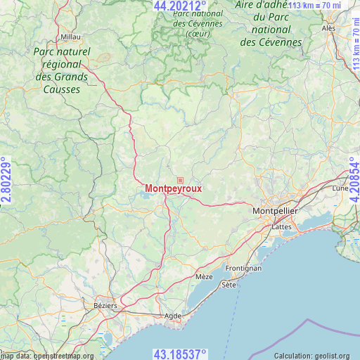
Montpeyroux GPS coordinates[2]
43° 41' 45.24" North, 3° 30' 19.512" East
| Map corner | latitude | longitude |
|---|---|---|
| Upper-left | 44.20212°, | 2.80229° |
| Center: | 43.6959°, | 3.50542° |
| Lower-right: | 43.18537°, | 4.20854° |
| Map W x H: | 113.1×113 km | = 70.3×70.2mi |
| max Lat: | 51.07786° ⇑90.5% North |
| Montpeyroux: | 43.6959° |
| min Lat: | ⇓9.5% South 41.3874° |
| min Long | Montpeyroux | max Long |
| -5.08615° | 3.50542° | 9.52242° |
| W 64.3%⇐ | ⇒35.7% E |
Elevation
Elevation of Montpeyroux is 152 m = 499 ft, and this is 41.7 m = 137 ft below average elevation for this country.
| Max E: |
2333 m = 7654 ft | 44.4% |
| Avg. | 193.7 m = 635 ft | |
| Montpeyroux | 152 m = 499 ft | |
Min E: |
-1 m = -3 ft | 55.6% |
See also: France elevation on elevation.city.
Geographical zone
Montpeyroux is located in North temperate zone (between Tropic of Cancer and the Arctic Circle). Distance of this Northern Tropic circle is 2252.6 km =1399.7 mi to South.| Distance of | km | miles | from Montpeyroux |
|---|---|---|---|
| North Pole | 5148.5 | 3199.1 | to North |
| Arctic Circle | 2542.6 | 1579.9 | to North |
| Tropic Cancer | 2252.6 | 1399.7 | to South |
| Equator | 4858.5 | 3018.9 | to South |


Nearby cities:
15 places around Montpeyroux: (largest is in red/bold)
• Aniane
6.7 km =4.2 mi,  100°
100°
• Argelliers
13.4 km =8.3 mi,  88°
88°
• Aspiran
15.1 km =9.4 mi,  197°
197°
• Gignac
6.1 km =3.8 mi,  143°
143°
• Le Bosc
9.7 km =6 mi,  278°
278°
• Le Pouget
11.7 km =7.3 mi,  172°
172°
• Nébian
11.6 km =7.2 mi,  210°
210°
• Plaissan
15.5 km =9.6 mi, 173°
• Pouzols
8.7 km =5.4 mi,  175°
175°
• Saint-André-de-Sangonis
5.4 km =3.4 mi, 182°
• Saint-Bauzille-de-la-Sylve
9.3 km =5.8 mi,  160°
160°
• Saint-Félix-de-Lodez
5.2 km =3.2 mi,  224°
224°
• Saint-Jean-de-Fos
3.8 km =2.4 mi,  81°
81°
• Soubès
15.1 km =9.4 mi,  301°
301°
• Vendémian
13.6 km =8.5 mi, 160°
Sources, notices
• [Note1] Compared only with cities in France existing in our database
• [Src1] Map data: © OpenStreetMap contributors (CC-BY-SA)
• [Src2] Other city data from geonames.org with taken over terms of usage.
• [Src3] Geographical zone / Annual Mean Temperature by Robert A. Rohde @ Wikipedia
