Soubès geodata
Soubès (Occitanie) is a populated place; located in France in Europe/Paris (GMT+2) time zone. With population of 808 people, there are 10506 cities with bigger population in this country. Compared to other cities in France, 89.5% of cities are located further ↑North; 62.6% of cities are located further ←West and 74% of cities have lower elevation than Soubès. Note1
Administrative division(s):
- Level 1: Occitanie
- Level 2: Département de l'Hérault
- Level 3: Arrondissement de Lodève
- Level 4: Soubès


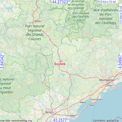
Soubès GPS coordinates[2]
43° 46' 3.432" North, 3° 20' 47.544" East
| Map corner | latitude | longitude |
|---|---|---|
| Upper-left | 44.27323°, | 2.64342° |
| Center: | 43.76762°, | 3.34654° |
| Lower-right: | 43.2577°, | 4.04967° |
| Map W x H: | 112.9×112.9 km | = 70.2×70.2mi |
| max Lat: | 51.07786° ⇑89.5% North |
| Soubès: | 43.76762° |
| min Lat: | ⇓10.5% South 41.3874° |
| min Long | Soubès | max Long |
| -5.08615° | 3.34654° | 9.52242° |
| W 62.6%⇐ | ⇒37.4% E |
Elevation
Elevation of Soubès is 242 m = 794 ft, and this is 48.3 m = 158 ft above average elevation for this country.
| Max E: |
2333 m = 7654 ft | 26% |
| Soubès | 242 m 794 ft | |
| Avg. | 193.7 m = 635 ft | |
Min E: |
-1 m = -3 ft | 74% |
See also: France elevation on elevation.city.
Geographical zone
Soubès is located in North temperate zone (between Tropic of Cancer and the Arctic Circle). Distance of this Northern Tropic circle is 2260.6 km =1404.7 mi to South.| Distance of | km | miles | from Soubès |
|---|---|---|---|
| North Pole | 5140.6 | 3194.2 | to North |
| Arctic Circle | 2534.7 | 1575 | to North |
| Tropic Cancer | 2260.6 | 1404.7 | to South |
| Equator | 4866.5 | 3023.9 | to South |


Nearby cities:
15 places around Soubès: (largest is in red/bold)
• Aniane
21.5 km =13.4 mi,  115°
115°
• Gignac
20.9 km =13 mi,  128°
128°
• Graissessac
22.5 km =14 mi,  243°
243°
• La Tour-sur-Orb
20.3 km =12.6 mi,  230°
230°
• Le Bosc
7.2 km =4.5 mi,  154°
154°
• Le Bousquet-d’Orb
16.6 km =10.3 mi, 239°
• Lodève
4.6 km =2.9 mi,  208°
208°
• Lunas
14.1 km =8.8 mi, 241°
• Montpeyroux
15.1 km =9.4 mi, 121°
• Nébian
19.2 km =11.9 mi,  159°
159°
• Pouzols
21.4 km =13.3 mi,  141°
141°
• Péret
21.8 km =13.5 mi,  169°
169°
• Saint-André-de-Sangonis
18.3 km =11.4 mi, 136°
• Saint-Félix-de-Lodez
14.9 km =9.3 mi, 142°
• Saint-Jean-de-Fos
18.1 km =11.2 mi,  114°
114°
Sources, notices
• [Note1] Compared only with cities in France existing in our database
• [Src1] Map data: © OpenStreetMap contributors (CC-BY-SA)
• [Src2] Other city data from geonames.org with taken over terms of usage.
• [Src3] Geographical zone / Annual Mean Temperature by Robert A. Rohde @ Wikipedia
