Saint-Bauzille-de-la-Sylve geodata
Saint-Bauzille-de-la-Sylve (Occitanie) is a populated place; located in France in Europe/Paris (GMT+2) time zone. With population of 822 people, there are 10372 cities with bigger population in this country. Compared to other cities in France, 91.6% of cities are located further ↑North; 64.6% of cities are located further ←West and 64.9% of cities have higher elevation than Saint-Bauzille-de-la-Sylve. Note1
Administrative division(s):
- Level 1: Occitanie
- Level 2: Département de l'Hérault
- Level 3: Arrondissement de Lodève
- Level 4: Saint-Bauzille-de-la-Sylve
Current local time in Saint-Bauzille-de-la-Sylve:
03:57 AM, SundayDifference from your time zone: hours


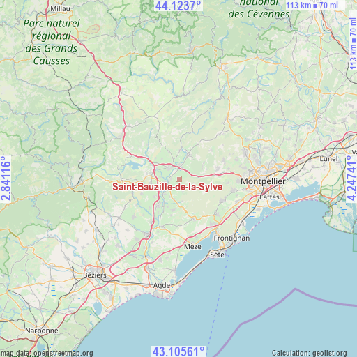
Saint-Bauzille-de-la-Sylve GPS coordinates[2]
43° 37' 0.516" North, 3° 32' 39.444" East
| Map corner | latitude | longitude |
|---|---|---|
| Upper-left | 44.1237°, | 2.84116° |
| Center: | 43.61681°, | 3.54429° |
| Lower-right: | 43.10561°, | 4.24741° |
| Map W x H: | 113.2×113.2 km | = 70.3×70.3mi |
| max Lat: | 51.07786° ⇑91.6% North |
| Saint-Bauzille-de-la-Sylve: | 43.61681° |
| min Lat: | ⇓8.4% South 41.3874° |
| min Long | Saint-Bauzille- | max Long |
| -5.08615° | 3.54429° | 9.52242° |
| W 64.6%⇐ | ⇒35.4% E |
Elevation
Elevation of Saint-Bauzille-de-la-Sylve is 90 m = 295 ft, and this is 103.7 m = 340 ft below average elevation for this country.
| Max E: |
2333 m = 7654 ft | 64.9% |
| Avg. | 193.7 m = 635 ft | |
| Saint-Bauzille-de-la-Sylve | 90 m = 295 ft | |
Min E: |
-1 m = -3 ft | 35.1% |
See also: France elevation on elevation.city.
Geographical zone
Saint-Bauzille-de-la-Sylve is located in North temperate zone (between Tropic of Cancer and the Arctic Circle). Distance of this Northern Tropic circle is 2243.8 km =1394.2 mi to South.| Distance of | km | miles | from Saint-Bauzille-de-la-Sylve |
|---|---|---|---|
| North Pole | 5157.3 | 3204.6 | to North |
| Arctic Circle | 2551.4 | 1585.4 | to North |
| Tropic Cancer | 2243.8 | 1394.2 | to South |
| Equator | 4849.7 | 3013.5 | to South |


Nearby cities:
15 places around Saint-Bauzille-de-la-Sylve: (largest is in red/bold)
• Aniane
8.3 km =5.2 mi,  24°
24°
• Aspiran
9.5 km =5.9 mi,  233°
233°
• Gignac
3.9 km =2.4 mi,  7°
7°
• Le Pouget
3.2 km =2 mi,  210°
210°
• Montpeyroux
9.3 km =5.8 mi,  340°
340°
• Nébian
9.2 km =5.7 mi,  262°
262°
• Paulhan
11.1 km =6.9 mi,  219°
219°
• Plaissan
6.8 km =4.2 mi,  192°
192°
• Pouzols
2.4 km =1.5 mi,  272°
272°
• Saint-André-de-Sangonis
4.8 km =3 mi,  315°
315°
• Saint-Félix-de-Lodez
8.5 km =5.3 mi,  306°
306°
• Saint-Jean-de-Fos
9.4 km =5.8 mi,  3°
3°
• Saint-Pargoire
10.1 km =6.3 mi, 191°
• Saint-Paul-et-Valmalle
10.6 km =6.6 mi,  83°
83°
• Vendémian
4.3 km =2.7 mi,  160°
160°
Sources, notices
• [Note1] Compared only with cities in France existing in our database
• [Src1] Map data: © OpenStreetMap contributors (CC-BY-SA)
• [Src2] Other city data from geonames.org with taken over terms of usage.
• [Src3] Geographical zone / Annual Mean Temperature by Robert A. Rohde @ Wikipedia
