Nébian geodata
Nébian (Occitanie) is a populated place; located in France in Europe/Paris (GMT+2) time zone. With population of 1,160 people, there are 7765 cities with bigger population in this country. Compared to other cities in France, 91.7% of cities are located further ↑North; 63.6% of cities are located further ←West and 52% of cities have higher elevation than Nébian. Note1
Administrative division(s):
- Level 1: Occitanie
- Level 2: Département de l'Hérault
- Level 3: Arrondissement de Lodève
- Level 4: Nébian


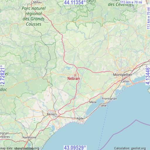
Nébian GPS coordinates[2]
43° 36' 23.652" North, 3° 25' 52.788" East
| Map corner | latitude | longitude |
|---|---|---|
| Upper-left | 44.11354°, | 2.72821° |
| Center: | 43.60657°, | 3.43133° |
| Lower-right: | 43.09529°, | 4.13446° |
| Map W x H: | 113.2×113.2 km | = 70.3×70.3mi |
| max Lat: | 51.07786° ⇑91.7% North |
| Nébian: | 43.60657° |
| min Lat: | ⇓8.3% South 41.3874° |
| min Long | Nébian | max Long |
| -5.08615° | 3.43133° | 9.52242° |
| W 63.6%⇐ | ⇒36.4% E |
Elevation
Elevation of Nébian is 125 m = 410 ft, and this is 68.7 m = 225 ft below average elevation for this country.
| Max E: |
2333 m = 7654 ft | 52% |
| Avg. | 193.7 m = 635 ft | |
| Nébian | 125 m = 410 ft | |
Min E: |
-1 m = -3 ft | 48% |
See also: France elevation on elevation.city.
Geographical zone
Nébian is located in North temperate zone (between Tropic of Cancer and the Arctic Circle). Distance of this Northern Tropic circle is 2242.7 km =1393.5 mi to South.| Distance of | km | miles | from Nébian |
|---|---|---|---|
| North Pole | 5158.5 | 3205.3 | to North |
| Arctic Circle | 2552.6 | 1586.1 | to North |
| Tropic Cancer | 2242.7 | 1393.5 | to South |
| Equator | 4848.6 | 3012.8 | to South |


Nearby cities:
15 places around Nébian: (largest is in red/bold)
• Adissan
8.1 km =5 mi,  182°
182°
• Aspiran
4.8 km =3 mi,  161°
161°
• Fontès
8.5 km =5.3 mi,  209°
209°
• Gignac
10.9 km =6.8 mi,  62°
62°
• Le Pouget
7.7 km =4.8 mi,  102°
102°
• Nizas
10.5 km =6.5 mi,  190°
190°
• Paulhan
7.8 km =4.8 mi, 164°
• Plaissan
9.4 km =5.8 mi,  125°
125°
• Pouzols
6.8 km =4.2 mi,  79°
79°
• Péret
4.5 km =2.8 mi,  218°
218°
• Saint-André-de-Sangonis
7.3 km =4.5 mi,  51°
51°
• Saint-Bauzille-de-la-Sylve
9.2 km =5.7 mi, 82°
• Saint-Félix-de-Lodez
6.6 km =4.1 mi,  20°
20°
• Saint-Pargoire
11.2 km =7 mi,  141°
141°
• Vendémian
10.9 km =6.8 mi,  105°
105°
Sources, notices
• [Note1] Compared only with cities in France existing in our database
• [Src1] Map data: © OpenStreetMap contributors (CC-BY-SA)
• [Src2] Other city data from geonames.org with taken over terms of usage.
• [Src3] Geographical zone / Annual Mean Temperature by Robert A. Rohde @ Wikipedia
