Montmerle-sur-Saône geodata
Montmerle-sur-Saône (Auvergne-Rhône-Alpes) is a populated place; located in France in Europe/Paris (GMT+2) time zone. With population of 3,104 people, there are 3142 cities with bigger population in this country. Compared to other cities in France, 65.3% of cities are located further ↑North; 74.6% of cities are located further ←West and 69.4% of cities have lower elevation than Montmerle-sur-Saône. Note1
Administrative division(s):
- Level 1: Auvergne-Rhône-Alpes
- Level 2: Département de l'Ain
- Level 3: Arrondissement de Bourg-en-Bresse
- Level 4: Montmerle-sur-Saône


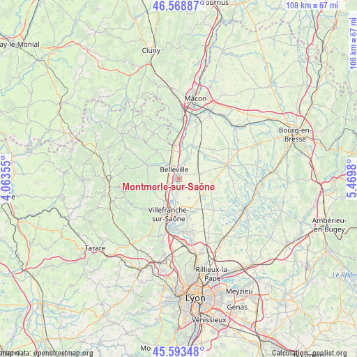
Montmerle-sur-Saône GPS coordinates[2]
46° 4' 59.988" North, 4° 46' 0.012" East
| Map corner | latitude | longitude |
|---|---|---|
| Upper-left | 46.56887°, | 4.06355° |
| Center: | 46.08333°, | 4.76667° |
| Lower-right: | 45.59348°, | 5.4698° |
| Map W x H: | 108.5×108.5 km | = 67.4×67.4mi |
| max Lat: | 51.07786° ⇑65.3% North |
| Montmerle-sur-Saône: | 46.08333° |
| min Lat: | ⇓34.7% South 41.3874° |
| min Long | Montmerle-sur-S | max Long |
| -5.08615° | 4.76667° | 9.52242° |
| W 74.6%⇐ | ⇒25.4% E |
Elevation
Elevation of Montmerle-sur-Saône is 216 m = 709 ft, and this is 22.3 m = 73 ft above average elevation for this country.
| Max E: |
2333 m = 7654 ft | 30.6% |
| Montmerle-sur-Saône | 216 m 709 ft | |
| Avg. | 193.7 m = 635 ft | |
Min E: |
-1 m = -3 ft | 69.4% |
See also: France elevation on elevation.city.
Geographical zone
Montmerle-sur-Saône is located in North temperate zone (between Tropic of Cancer and the Arctic Circle). Distance of this North polar circle is 2277.2 km =1415 mi to North.| Distance of | km | miles | from Montmerle-sur-Saône |
|---|---|---|---|
| North Pole | 4883.1 | 3034.2 | to North |
| Arctic Circle | 2277.2 | 1415 | to North |
| Tropic Cancer | 2518.1 | 1564.7 | to South |
| Equator | 5124 | 3183.9 | to South |


Nearby cities:
15 places around Montmerle-sur-Saône: (largest is in red/bold)
• Arnas
8 km =5 mi,  214°
214°
• Belleville
3.1 km =1.9 mi,  334°
334°
• Cercié
8.4 km =5.2 mi,  298°
298°
• Chaleins
6.6 km =4.1 mi,  151°
151°
• Chaneins
6.8 km =4.2 mi,  76°
76°
• Charentay
6.8 km =4.2 mi,  275°
275°
• Dracé
8.2 km =5.1 mi,  359°
359°
• Fareins
7.2 km =4.5 mi,  183°
183°
• Francheleins
3.4 km =2.1 mi,  106°
106°
• Guéreins
2.3 km =1.4 mi,  11°
11°
• Mogneneins
7.1 km =4.4 mi,  28°
28°
• Montceaux
2.8 km =1.7 mi,  59°
59°
• Saint-Georges-de-Reneins
4.2 km =2.6 mi,  235°
235°
• Saint-Lager
7.9 km =4.9 mi,  293°
293°
• Taponas
4.3 km =2.7 mi,  0°
0°
Sources, notices
• [Note1] Compared only with cities in France existing in our database
• [Src1] Map data: © OpenStreetMap contributors (CC-BY-SA)
• [Src2] Other city data from geonames.org with taken over terms of usage.
• [Src3] Geographical zone / Annual Mean Temperature by Robert A. Rohde @ Wikipedia
