Arnas geodata
Arnas (Auvergne-Rhône-Alpes) is a populated place; located in France in Europe/Paris (GMT+2) time zone. With population of 3,332 people, there are 2925 cities with bigger population in this country. Compared to other cities in France, 66% of cities are located further ↑North; 73.9% of cities are located further ←West and 62.4% of cities have lower elevation than Arnas. Note1
Administrative division(s):
- Level 1: Auvergne-Rhône-Alpes
- Level 2: Département du Rhône
- Level 3: Arrondissement de Villefranche-sur-Saône
- Level 4: Arnas


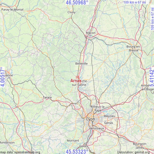
Arnas GPS coordinates[2]
46° 1' 24.996" North, 4° 42' 29.88" East
| Map corner | latitude | longitude |
|---|---|---|
| Upper-left | 46.50968°, | 4.00517° |
| Center: | 46.02361°, | 4.7083° |
| Lower-right: | 45.53323°, | 5.41142° |
| Map W x H: | 108.6×108.6 km | = 67.5×67.5mi |
| max Lat: | 51.07786° ⇑66% North |
| Arnas: | 46.02361° |
| min Lat: | ⇓34% South 41.3874° |
| min Long | Arnas | max Long |
| -5.08615° | 4.7083° | 9.52242° |
| W 73.9%⇐ | ⇒26.1% E |
Elevation
Elevation of Arnas is 181 m = 594 ft, and this is 12.7 m = 42 ft below average elevation for this country.
| Max E: |
2333 m = 7654 ft | 37.6% |
| Avg. | 193.7 m = 635 ft | |
| Arnas | 181 m = 594 ft | |
Min E: |
-1 m = -3 ft | 62.4% |
See also: France elevation on elevation.city.
Geographical zone
Arnas is located in North temperate zone (between Tropic of Cancer and the Arctic Circle). Distance of this North polar circle is 2283.8 km =1419.1 mi to North.| Distance of | km | miles | from Arnas |
|---|---|---|---|
| North Pole | 4889.7 | 3038.3 | to North |
| Arctic Circle | 2283.8 | 1419.1 | to North |
| Tropic Cancer | 2511.4 | 1560.5 | to South |
| Equator | 5117.3 | 3179.7 | to South |


Nearby cities:
15 places around Arnas: (largest is in red/bold)
• Beauregard
4.5 km =2.8 mi,  127°
127°
• Blacé
5 km =3.1 mi,  280°
280°
• Cogny
7.6 km =4.7 mi,  238°
238°
• Denicé
5.4 km =3.4 mi, 243°
• Fareins
4.1 km =2.5 mi,  96°
96°
• Frans
6.4 km =4 mi,  122°
122°
• Gleizé
3.9 km =2.4 mi,  192°
192°
• Jassans-Riottier
6.2 km =3.9 mi,  138°
138°
• Lacenas
6.4 km =4 mi,  230°
230°
• Liergues
6.8 km =4.2 mi,  211°
211°
• Limas
5.3 km =3.3 mi,  182°
182°
• Saint-Georges-de-Reneins
4.4 km =2.7 mi,  13°
13°
• Saint-Julien
4.3 km =2.7 mi,  273°
273°
• Saint-Étienne-des-Oullières
6.7 km =4.2 mi,  316°
316°
• Villefranche-sur-Saône
3.9 km =2.4 mi,  166°
166°
Sources, notices
• [Note1] Compared only with cities in France existing in our database
• [Src1] Map data: © OpenStreetMap contributors (CC-BY-SA)
• [Src2] Other city data from geonames.org with taken over terms of usage.
• [Src3] Geographical zone / Annual Mean Temperature by Robert A. Rohde @ Wikipedia
