Belleville geodata
Belleville (Auvergne-Rhône-Alpes) is a populated place; located in France in Europe/Paris (GMT+2) time zone. With population of 6,299 people, there are 1574 cities with bigger population in this country. Compared to other cities in France, 64.9% of cities are located further ↑North; 74.3% of cities are located further ←West and 60.7% of cities have lower elevation than Belleville. Note1
Administrative division(s):
- Level 1: Auvergne-Rhône-Alpes
- Level 2: Département du Rhône
- Level 3: Arrondissement de Villefranche-sur-Saône
- Level 4: Belleville-en-Beaujolais


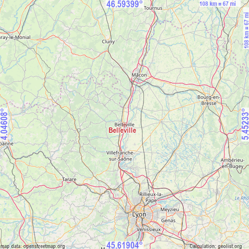
Belleville GPS coordinates[2]
46° 6' 31.212" North, 4° 44' 57.12" East
| Map corner | latitude | longitude |
|---|---|---|
| Upper-left | 46.59399°, | 4.04608° |
| Center: | 46.10867°, | 4.7492° |
| Lower-right: | 45.61904°, | 5.45233° |
| Map W x H: | 108.4×108.4 km | = 67.4×67.4mi |
| max Lat: | 51.07786° ⇑64.9% North |
| Belleville: | 46.10867° |
| min Lat: | ⇓35.1% South 41.3874° |
| min Long | Belleville | max Long |
| -5.08615° | 4.7492° | 9.52242° |
| W 74.3%⇐ | ⇒25.7% E |
Elevation
Elevation of Belleville is 173 m = 568 ft, and this is 20.7 m = 68 ft below average elevation for this country.
| Max E: |
2333 m = 7654 ft | 39.3% |
| Avg. | 193.7 m = 635 ft | |
| Belleville | 173 m = 568 ft | |
Min E: |
-1 m = -3 ft | 60.7% |
See also: France elevation on elevation.city.
Geographical zone
Belleville is located in North temperate zone (between Tropic of Cancer and the Arctic Circle). Distance of this North polar circle is 2274.4 km =1413.2 mi to North.| Distance of | km | miles | from Belleville |
|---|---|---|---|
| North Pole | 4880.3 | 3032.5 | to North |
| Arctic Circle | 2274.4 | 1413.2 | to North |
| Tropic Cancer | 2520.9 | 1566.4 | to South |
| Equator | 5126.8 | 3185.6 | to South |


Nearby cities:
15 places around Belleville: (largest is in red/bold)
• Cercié
6.2 km =3.9 mi,  281°
281°
• Charentay
5.8 km =3.6 mi,  247°
247°
• Corcelles-en-Beaujolais
5.4 km =3.4 mi,  338°
338°
• Dracé
5.5 km =3.4 mi,  13°
13°
• Durette
7.7 km =4.8 mi,  292°
292°
• Francheleins
6 km =3.7 mi,  129°
129°
• Guéreins
1.9 km =1.2 mi,  107°
107°
• Lancié
7.4 km =4.6 mi, 338°
• Mogneneins
5.8 km =3.6 mi,  54°
54°
• Montceaux
4 km =2.5 mi, 111°
• Montmerle-sur-Saône
3.1 km =1.9 mi,  154°
154°
• Saint-Georges-de-Reneins
5.6 km =3.5 mi,  202°
202°
• Saint-Lager
5.9 km =3.7 mi,  273°
273°
• Taponas
2 km =1.2 mi,  43°
43°
• Villié-Morgon
8 km =5 mi,  318°
318°
In other languages:
- In Spanish: Belleville sobre Saona
- In France: Belleville-sur-Saône
- In German: Belleville-sur-Saône
Sources, notices
• [Note1] Compared only with cities in France existing in our database
• [Src1] Map data: © OpenStreetMap contributors (CC-BY-SA)
• [Src2] Other city data from geonames.org with taken over terms of usage.
• [Src3] Geographical zone / Annual Mean Temperature by Robert A. Rohde @ Wikipedia
