Monticello geodata
Monticello (Corsica) is a populated place; located in France in Europe/Paris (GMT+2) time zone. With population of 1,388 people, there are 6657 cities with bigger population in this country. Compared to other cities in France, 99.2% of cities are located further ↑North; 99.6% of cities are located further ←West and 71.8% of cities have lower elevation than Monticello. Note1
Administrative division(s):
- Level 1: Corsica
- Level 2: Département de la Haute-Corse
- Level 3: Arrondissement de Calvi
- Level 4: Monticello


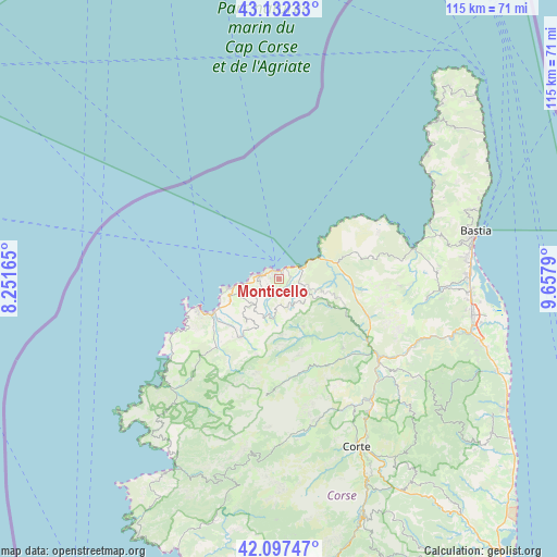
Monticello GPS coordinates[2]
42° 37' 1.38" North, 8° 57' 17.172" East
| Map corner | latitude | longitude |
|---|---|---|
| Upper-left | 43.13233°, | 8.25165° |
| Center: | 42.61705°, | 8.95477° |
| Lower-right: | 42.09747°, | 9.6579° |
| Map W x H: | 115.1×115.1 km | = 71.5×71.5mi |
| max Lat: | 51.07786° ⇑99.2% North |
| Monticello: | 42.61705° |
| min Lat: | ⇓0.8% South 41.3874° |
| min Long | Monticello | max Long |
| -5.08615° | 8.95477° | 9.52242° |
| W 99.6%⇐ | ⇒0.40000000000001% E |
Elevation
Elevation of Monticello is 229 m = 751 ft, and this is 35.3 m = 116 ft above average elevation for this country.
| Max E: |
2333 m = 7654 ft | 28.2% |
| Monticello | 229 m 751 ft | |
| Avg. | 193.7 m = 635 ft | |
Min E: |
-1 m = -3 ft | 71.8% |
See also: France elevation on elevation.city.
Geographical zone
Monticello is located in North temperate zone (between Tropic of Cancer and the Arctic Circle). Distance of this Northern Tropic circle is 2132.7 km =1325.2 mi to South.| Distance of | km | miles | from Monticello |
|---|---|---|---|
| North Pole | 5268.5 | 3273.7 | to North |
| Arctic Circle | 2662.6 | 1654.5 | to North |
| Tropic Cancer | 2132.7 | 1325.2 | to South |
| Equator | 4738.6 | 2944.4 | to South |


Nearby cities:
15 places around Monticello: (largest is in red/bold)
• Aregno
6.4 km =4 mi,  231°
231°
• Calenzana
14.6 km =9.1 mi,  214°
214°
• Calvi
17.1 km =10.6 mi,  250°
250°
• Corbara
4 km =2.5 mi,  265°
265°
• L'Île-Rousse
2.3 km =1.4 mi,  322°
322°
• Lumio
10.8 km =6.7 mi, 246°
• Moltifao
19.5 km =12.1 mi,  138°
138°
• Morosaglia
34.8 km =21.6 mi,  125°
125°
• Murato
30.8 km =19.1 mi,  98°
98°
• Oletta
32.7 km =20.3 mi,  87°
87°
• Omessa
34 km =21.1 mi, 143°
• Patrimonio
34.5 km =21.4 mi,  74°
74°
• Saint-Florent
29.4 km =18.3 mi,  75°
75°
• Santa-Reparata-di-Balagna
2.6 km =1.6 mi,  235°
235°
• Vignale
34.5 km =21.4 mi,  118°
118°
Sources, notices
• [Note1] Compared only with cities in France existing in our database
• [Src1] Map data: © OpenStreetMap contributors (CC-BY-SA)
• [Src2] Other city data from geonames.org with taken over terms of usage.
• [Src3] Geographical zone / Annual Mean Temperature by Robert A. Rohde @ Wikipedia
