Patrimonio geodata
Patrimonio (Corsica) is a populated place; located in France in Europe/Paris (GMT+2) time zone. With population of 665 people, there are 12292 cities with bigger population in this country. Compared to other cities in France, 99% of cities are located further ↑North; 99.8% of cities are located further ←West and 59.1% of cities have higher elevation than Patrimonio. Note1
Administrative division(s):
- Level 1: Corsica
- Level 2: Département de la Haute-Corse
- Level 3: Arrondissement de Calvi
- Level 4: Patrimonio


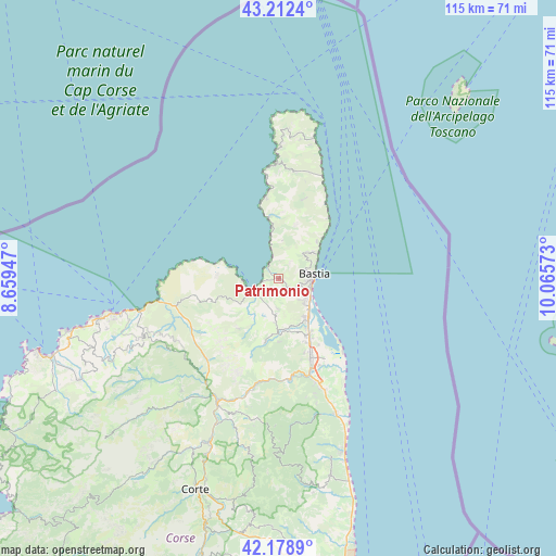
Patrimonio GPS coordinates[2]
42° 41' 52.08" North, 9° 21' 45.36" East
| Map corner | latitude | longitude |
|---|---|---|
| Upper-left | 43.2124°, | 8.65947° |
| Center: | 42.6978°, | 9.3626° |
| Lower-right: | 42.1789°, | 10.06573° |
| Map W x H: | 114.9×114.9 km | = 71.4×71.4mi |
| max Lat: | 51.07786° ⇑99% North |
| Patrimonio: | 42.6978° |
| min Lat: | ⇓1% South 41.3874° |
| min Long | Patrimonio | max Long |
| -5.08615° | 9.3626° | 9.52242° |
| W 99.8%⇐ | ⇒0.2% E |
Elevation
Elevation of Patrimonio is 105 m = 344 ft, and this is 88.7 m = 291 ft below average elevation for this country.
| Max E: |
2333 m = 7654 ft | 59.1% |
| Avg. | 193.7 m = 635 ft | |
| Patrimonio | 105 m = 344 ft | |
Min E: |
-1 m = -3 ft | 40.9% |
See also: France elevation on elevation.city.
Geographical zone
Patrimonio is located in North temperate zone (between Tropic of Cancer and the Arctic Circle). Distance of this Northern Tropic circle is 2141.6 km =1330.7 mi to South.| Distance of | km | miles | from Patrimonio |
|---|---|---|---|
| North Pole | 5259.5 | 3268.1 | to North |
| Arctic Circle | 2653.6 | 1648.9 | to North |
| Tropic Cancer | 2141.6 | 1330.7 | to South |
| Equator | 4747.6 | 2950 | to South |


Nearby cities:
15 places around Patrimonio: (largest is in red/bold)
• Bastia
7.2 km =4.5 mi,  85°
85°
• Biguglia
9.2 km =5.7 mi,  149°
149°
• Borgo
16.7 km =10.4 mi,  161°
161°
• Brando
10.5 km =6.5 mi,  42°
42°
• Furiani
6.1 km =3.8 mi,  135°
135°
• Lucciana
17.5 km =10.9 mi, 164°
• Marine de Pietracorbara
18.1 km =11.2 mi,  31°
31°
• Marine de Sisco
16.2 km =10.1 mi, 39°
• Murato
13.6 km =8.5 mi,  192°
192°
• Oletta
7.6 km =4.7 mi, 185°
• Pietranera
8.2 km =5.1 mi,  69°
69°
• Saint-Florent
5.1 km =3.2 mi,  249°
249°
• San-Martino-di-Lota
7.3 km =4.5 mi,  59°
59°
• Santa-Maria-di-Lota
7.9 km =4.9 mi,  45°
45°
• Sisco
12.7 km =7.9 mi, 26°
Sources, notices
• [Note1] Compared only with cities in France existing in our database
• [Src1] Map data: © OpenStreetMap contributors (CC-BY-SA)
• [Src2] Other city data from geonames.org with taken over terms of usage.
• [Src3] Geographical zone / Annual Mean Temperature by Robert A. Rohde @ Wikipedia
