Aregno geodata
Aregno (Corsica) is a populated place; located in France in Europe/Paris (GMT+2) time zone. With population of 615 people, there are 13071 cities with bigger population in this country. Compared to other cities in France, 99.3% of cities are located further ↑North; 99.5% of cities are located further ←West and 74.8% of cities have lower elevation than Aregno. Note1
Administrative division(s):
- Level 1: Corsica
- Level 2: Département de la Haute-Corse
- Level 3: Arrondissement de Calvi
- Level 4: Aregno


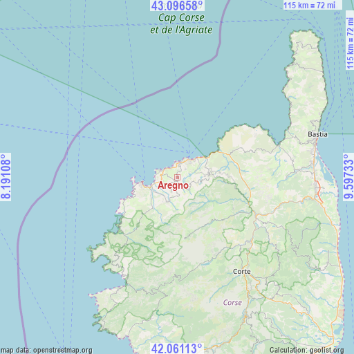
Aregno GPS coordinates[2]
42° 34' 51.6" North, 8° 53' 39.156" East
| Map corner | latitude | longitude |
|---|---|---|
| Upper-left | 43.09658°, | 8.19108° |
| Center: | 42.581°, | 8.89421° |
| Lower-right: | 42.06113°, | 9.59733° |
| Map W x H: | 115.1×115.1 km | = 71.5×71.5mi |
| max Lat: | 51.07786° ⇑99.3% North |
| Aregno: | 42.581° |
| min Lat: | ⇓0.7% South 41.3874° |
| min Long | Aregno | max Long |
| -5.08615° | 8.89421° | 9.52242° |
| W 99.5%⇐ | ⇒0.5% E |
Elevation
Elevation of Aregno is 247 m = 810 ft, and this is 53.3 m = 175 ft above average elevation for this country.
| Max E: |
2333 m = 7654 ft | 25.2% |
| Aregno | 247 m 810 ft | |
| Avg. | 193.7 m = 635 ft | |
Min E: |
-1 m = -3 ft | 74.8% |
See also: France elevation on elevation.city.
Geographical zone
Aregno is located in North temperate zone (between Tropic of Cancer and the Arctic Circle). Distance of this Northern Tropic circle is 2128.6 km =1322.7 mi to South.| Distance of | km | miles | from Aregno |
|---|---|---|---|
| North Pole | 5272.5 | 3276.2 | to North |
| Arctic Circle | 2666.6 | 1656.9 | to North |
| Tropic Cancer | 2128.6 | 1322.7 | to South |
| Equator | 4734.6 | 2941.9 | to South |


Nearby cities:
15 places around Aregno: (largest is in red/bold)
• Calenzana
8.7 km =5.4 mi,  201°
201°
• Calvi
11.3 km =7 mi,  261°
261°
• Corbara
3.9 km =2.4 mi,  15°
15°
• Corte
36.7 km =22.8 mi,  145°
145°
• L'Île-Rousse
6.9 km =4.3 mi,  31°
31°
• Lumio
5 km =3.1 mi,  267°
267°
• Moltifao
20.9 km =13 mi,  120°
120°
• Monticello
6.4 km =4 mi,  51°
51°
• Morosaglia
37 km =23 mi, 115°
• Murato
35.4 km =22 mi,  90°
90°
• Omessa
34.3 km =21.3 mi,  133°
133°
• Ota
37.9 km =23.5 mi, 198°
• Saint-Florent
35.3 km =21.9 mi,  71°
71°
• Santa-Reparata-di-Balagna
3.8 km =2.4 mi, 47°
• Vignale
37.5 km =23.3 mi,  109°
109°
Sources, notices
• [Note1] Compared only with cities in France existing in our database
• [Src1] Map data: © OpenStreetMap contributors (CC-BY-SA)
• [Src2] Other city data from geonames.org with taken over terms of usage.
• [Src3] Geographical zone / Annual Mean Temperature by Robert A. Rohde @ Wikipedia
