Gespunsart geodata
Gespunsart (Grand Est) is a populated place; located in France in Europe/Paris (GMT+2) time zone. With population of 1,114 people, there are 8044 cities with bigger population in this country. Compared to other cities in France, 92.4% of cities are located further ↓South; 75.5% of cities are located further ←West and 66.6% of cities have lower elevation than Gespunsart. Note1
Administrative division(s):
- Level 1: Grand Est
- Level 2: Ardennes
- Level 3: Arrondissement de Charleville-Mézières
- Level 4: Gespunsart


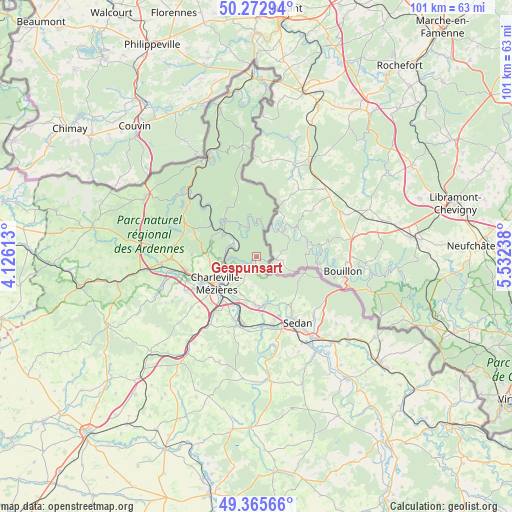
Gespunsart GPS coordinates[2]
49° 49' 17.148" North, 4° 49' 45.336" East
| Map corner | latitude | longitude |
|---|---|---|
| Upper-left | 50.27294°, | 4.12613° |
| Center: | 49.82143°, | 4.82926° |
| Lower-right: | 49.36566°, | 5.53238° |
| Map W x H: | 100.9×100.9 km | = 62.7×62.7mi |
| max Lat: | 51.07786° ⇑7.6% North |
| Gespunsart: | 49.82143° |
| min Lat: | ⇓92.4% South 41.3874° |
| min Long | Gespunsart | max Long |
| -5.08615° | 4.82926° | 9.52242° |
| W 75.5%⇐ | ⇒24.5% E |
Elevation
Elevation of Gespunsart is 202 m = 663 ft, and this is 8.3 m = 27 ft above average elevation for this country.
| Max E: |
2333 m = 7654 ft | 33.4% |
| Gespunsart | 202 m 663 ft | |
| Avg. | 193.7 m = 635 ft | |
Min E: |
-1 m = -3 ft | 66.6% |
See also: France elevation on elevation.city.
Geographical zone
Gespunsart is located in North temperate zone (between Tropic of Cancer and the Arctic Circle). Distance of this North polar circle is 1861.6 km =1156.7 mi to North.| Distance of | km | miles | from Gespunsart |
|---|---|---|---|
| North Pole | 4467.4 | 2775.9 | to North |
| Arctic Circle | 1861.6 | 1156.7 | to North |
| Tropic Cancer | 2933.7 | 1822.9 | to South |
| Equator | 5539.6 | 3442.1 | to South |


Nearby cities:
15 places around Gespunsart: (largest is in red/bold)
• Aiglemont
6.5 km =4 mi,  225°
225°
• Charleville-Mézières
9.5 km =5.9 mi, 231°
• Joigny-sur-Meuse
5.2 km =3.2 mi,  290°
290°
• La Grandville
5.2 km =3.2 mi,  208°
208°
• Les Hautes-Rivières
7.2 km =4.5 mi,  7°
7°
• Lumes
10.1 km =6.3 mi,  197°
197°
• Montcy-Notre-Dame
8.1 km =5 mi, 230°
• Monthermé
10 km =6.2 mi,  314°
314°
• Neufmanil
2.6 km =1.6 mi,  243°
243°
• Nouzonville
5.9 km =3.7 mi,  261°
261°
• Saint-Laurent
7.6 km =4.7 mi, 213°
• Thilay
6 km =3.7 mi,  345°
345°
• Villers-Semeuse
10.6 km =6.6 mi, 213°
• Vivier-au-Court
9.8 km =6.1 mi,  179°
179°
• Vrigne-aux-Bois
9.6 km =6 mi,  168°
168°
Sources, notices
• [Note1] Compared only with cities in France existing in our database
• [Src1] Map data: © OpenStreetMap contributors (CC-BY-SA)
• [Src2] Other city data from geonames.org with taken over terms of usage.
• [Src3] Geographical zone / Annual Mean Temperature by Robert A. Rohde @ Wikipedia
