Montfort-sur-Argens geodata
Montfort-sur-Argens (Provence-Alpes-Côte d'Azur) is a seat of a fourth-order administrative division; located in France in Europe/Paris (GMT+2) time zone. With population of 944 people, there are 9259 cities with bigger population in this country. Compared to other cities in France, 93.4% of cities are located further ↑North; 88.4% of cities are located further ←West and 56.1% of cities have lower elevation than Montfort-sur-Argens. Note1
Administrative division(s):
- Level 1: Provence-Alpes-Côte d'Azur
- Level 2: Var
- Level 3: Arrondissement de Brignoles
- Level 4: Montfort-sur-Argens


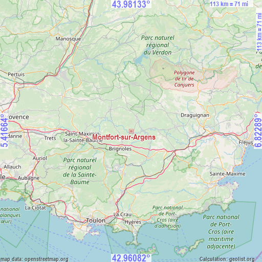
Montfort-sur-Argens GPS coordinates[2]
43° 28' 23.628" North, 6° 7' 11.136" East
| Map corner | latitude | longitude |
|---|---|---|
| Upper-left | 43.98133°, | 5.41664° |
| Center: | 43.47323°, | 6.11976° |
| Lower-right: | 42.96082°, | 6.82289° |
| Map W x H: | 113.5×113.5 km | = 70.5×70.5mi |
| max Lat: | 51.07786° ⇑93.4% North |
| Montfort-sur-Argens: | 43.47323° |
| min Lat: | ⇓6.6% South 41.3874° |
| min Long | Montfort-sur-Ar | max Long |
| -5.08615° | 6.11976° | 9.52242° |
| W 88.4%⇐ | ⇒11.6% E |
Elevation
Elevation of Montfort-sur-Argens is 154 m = 505 ft, and this is 39.7 m = 130 ft below average elevation for this country.
| Max E: |
2333 m = 7654 ft | 43.9% |
| Avg. | 193.7 m = 635 ft | |
| Montfort-sur-Argens | 154 m = 505 ft | |
Min E: |
-1 m = -3 ft | 56.1% |
See also: France elevation on elevation.city.
Geographical zone
Montfort-sur-Argens is located in North temperate zone (between Tropic of Cancer and the Arctic Circle). Distance of this Northern Tropic circle is 2227.9 km =1384.4 mi to South.| Distance of | km | miles | from Montfort-sur-Argens |
|---|---|---|---|
| North Pole | 5173.3 | 3214.5 | to North |
| Arctic Circle | 2567.4 | 1595.3 | to North |
| Tropic Cancer | 2227.9 | 1384.4 | to South |
| Equator | 4833.8 | 3003.6 | to South |


Nearby cities:
15 places around Montfort-sur-Argens: (largest is in red/bold)
• Barjols
13.1 km =8.1 mi,  316°
316°
• Bras
13.3 km =8.3 mi,  269°
269°
• Brignoles
8.8 km =5.5 mi,  212°
212°
• Cabasse
9.6 km =6 mi,  122°
122°
• Camps-la-Source
9.9 km =6.2 mi,  191°
191°
• Carcès
5.1 km =3.2 mi,  86°
86°
• Correns
3.6 km =2.2 mi,  296°
296°
• Cotignac
6.6 km =4.1 mi,  21°
21°
• Entrecasteaux
10.9 km =6.8 mi,  64°
64°
• La Celle
10.9 km =6.8 mi,  217°
217°
• Le Val
5.3 km =3.3 mi, 224°
• Pontevès
11.5 km =7.1 mi, 320°
• Salernes
13.6 km =8.5 mi,  42°
42°
• Sillans-la-Cascade
11.6 km =7.2 mi, 24°
• Vins-sur-Caramy
4.7 km =2.9 mi,  157°
157°
Sources, notices
• [Note1] Compared only with cities in France existing in our database
• [Src1] Map data: © OpenStreetMap contributors (CC-BY-SA)
• [Src2] Other city data from geonames.org with taken over terms of usage.
• [Src3] Geographical zone / Annual Mean Temperature by Robert A. Rohde @ Wikipedia
