Cabasse geodata
Cabasse (Provence-Alpes-Côte d'Azur) is a populated place; located in France in Europe/Paris (GMT+2) time zone. With population of 1,390 people, there are 6649 cities with bigger population in this country. Compared to other cities in France, 94% of cities are located further ↑North; 89.5% of cities are located further ←West and 66.1% of cities have lower elevation than Cabasse. Note1
Administrative division(s):
- Level 1: Provence-Alpes-Côte d'Azur
- Level 2: Var
- Level 3: Arrondissement de Brignoles
- Level 4: Cabasse


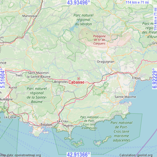
Cabasse GPS coordinates[2]
43° 25' 35.256" North, 6° 13' 9.012" East
| Map corner | latitude | longitude |
|---|---|---|
| Upper-left | 43.93496°, | 5.51604° |
| Center: | 43.42646°, | 6.21917° |
| Lower-right: | 42.91366°, | 6.92229° |
| Map W x H: | 113.6×113.6 km | = 70.6×70.6mi |
| max Lat: | 51.07786° ⇑94% North |
| Cabasse: | 43.42646° |
| min Lat: | ⇓6% South 41.3874° |
| min Long | Cabasse | max Long |
| -5.08615° | 6.21917° | 9.52242° |
| W 89.5%⇐ | ⇒10.5% E |
Elevation
Elevation of Cabasse is 199 m = 653 ft, and this is 5.3 m = 17 ft above average elevation for this country.
| Max E: |
2333 m = 7654 ft | 33.9% |
| Cabasse | 199 m 653 ft | |
| Avg. | 193.7 m = 635 ft | |
Min E: |
-1 m = -3 ft | 66.1% |
See also: France elevation on elevation.city.
Geographical zone
Cabasse is located in North temperate zone (between Tropic of Cancer and the Arctic Circle). Distance of this Northern Tropic circle is 2222.7 km =1381.1 mi to South.| Distance of | km | miles | from Cabasse |
|---|---|---|---|
| North Pole | 5178.5 | 3217.8 | to North |
| Arctic Circle | 2572.6 | 1598.5 | to North |
| Tropic Cancer | 2222.7 | 1381.1 | to South |
| Equator | 4828.6 | 3000.4 | to South |


Nearby cities:
15 places around Cabasse: (largest is in red/bold)
• Besse-sur-Issole
9.3 km =5.8 mi,  201°
201°
• Brignoles
12.9 km =8 mi,  259°
259°
• Camps-la-Source
10.9 km =6.8 mi,  245°
245°
• Carcès
6.2 km =3.9 mi,  331°
331°
• Cotignac
12.7 km =7.9 mi, 333°
• Entrecasteaux
10.1 km =6.3 mi,  10°
10°
• Flassans-sur-Issole
6.4 km =4 mi,  178°
178°
• Gonfaron
13.1 km =8.1 mi,  154°
154°
• Le Cannet-des-Maures
10.4 km =6.5 mi,  111°
111°
• Le Luc
8.3 km =5.2 mi,  115°
115°
• Le Thoronet
7.4 km =4.6 mi,  67°
67°
• Le Val
11.9 km =7.4 mi,  276°
276°
• Montfort-sur-Argens
9.6 km =6 mi,  302°
302°
• Sainte-Anastasie-sur-Issole
12 km =7.5 mi,  219°
219°
• Vins-sur-Caramy
6.3 km =3.9 mi, 277°
Sources, notices
• [Note1] Compared only with cities in France existing in our database
• [Src1] Map data: © OpenStreetMap contributors (CC-BY-SA)
• [Src2] Other city data from geonames.org with taken over terms of usage.
• [Src3] Geographical zone / Annual Mean Temperature by Robert A. Rohde @ Wikipedia
