Entrecasteaux geodata
Entrecasteaux (Provence-Alpes-Côte d'Azur) is a populated place; located in France in Europe/Paris (GMT+2) time zone. With population of 930 people, there are 9390 cities with bigger population in this country. Compared to other cities in France, 92.9% of cities are located further ↑North; 89.7% of cities are located further ←West and 73.3% of cities have lower elevation than Entrecasteaux. Note1
Administrative division(s):
- Level 1: Provence-Alpes-Côte d'Azur
- Level 2: Var
- Level 3: Arrondissement de Brignoles
- Level 4: Entrecasteaux


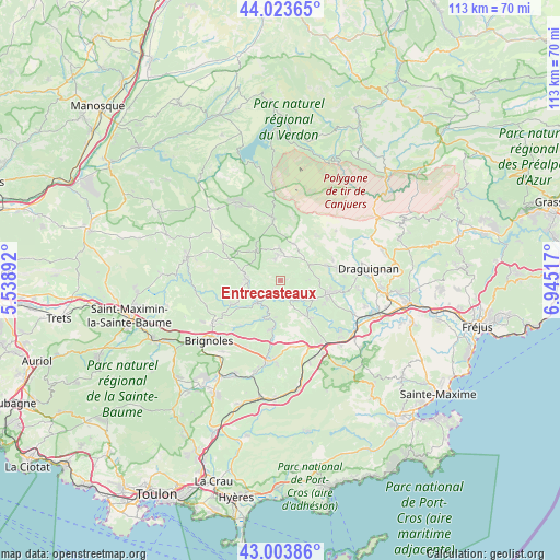
Entrecasteaux GPS coordinates[2]
43° 30' 57.276" North, 6° 14' 31.344" East
| Map corner | latitude | longitude |
|---|---|---|
| Upper-left | 44.02365°, | 5.53892° |
| Center: | 43.51591°, | 6.24204° |
| Lower-right: | 43.00386°, | 6.94517° |
| Map W x H: | 113.4×113.4 km | = 70.5×70.5mi |
| max Lat: | 51.07786° ⇑92.9% North |
| Entrecasteaux: | 43.51591° |
| min Lat: | ⇓7.1% South 41.3874° |
| min Long | Entrecasteaux | max Long |
| -5.08615° | 6.24204° | 9.52242° |
| W 89.7%⇐ | ⇒10.3% E |
Elevation
Elevation of Entrecasteaux is 238 m = 781 ft, and this is 44.3 m = 145 ft above average elevation for this country.
| Max E: |
2333 m = 7654 ft | 26.7% |
| Entrecasteaux | 238 m 781 ft | |
| Avg. | 193.7 m = 635 ft | |
Min E: |
-1 m = -3 ft | 73.3% |
See also: France elevation on elevation.city.
Geographical zone
Entrecasteaux is located in North temperate zone (between Tropic of Cancer and the Arctic Circle). Distance of this Northern Tropic circle is 2232.6 km =1387.3 mi to South.| Distance of | km | miles | from Entrecasteaux |
|---|---|---|---|
| North Pole | 5168.5 | 3211.6 | to North |
| Arctic Circle | 2562.7 | 1592.4 | to North |
| Tropic Cancer | 2232.6 | 1387.3 | to South |
| Equator | 4838.5 | 3006.5 | to South |


Nearby cities:
15 places around Entrecasteaux: (largest is in red/bold)
• Aups
12.6 km =7.8 mi,  353°
353°
• Cabasse
10.1 km =6.3 mi,  190°
190°
• Carcès
6.5 km =4 mi,  227°
227°
• Correns
13.5 km =8.4 mi,  256°
256°
• Cotignac
7.6 km =4.7 mi,  280°
280°
• Flayosc
12.6 km =7.8 mi,  80°
80°
• Le Luc
14.6 km =9.1 mi,  157°
157°
• Le Thoronet
8.7 km =5.4 mi,  145°
145°
• Lorgues
10 km =6.2 mi,  104°
104°
• Montfort-sur-Argens
10.9 km =6.8 mi,  244°
244°
• Salernes
5.3 km =3.3 mi, 352°
• Sillans-la-Cascade
7.6 km =4.7 mi,  318°
318°
• Tourtour
9.5 km =5.9 mi,  30°
30°
• Villecroze
7.9 km =4.9 mi,  20°
20°
• Vins-sur-Caramy
12.2 km =7.6 mi,  221°
221°
Sources, notices
• [Note1] Compared only with cities in France existing in our database
• [Src1] Map data: © OpenStreetMap contributors (CC-BY-SA)
• [Src2] Other city data from geonames.org with taken over terms of usage.
• [Src3] Geographical zone / Annual Mean Temperature by Robert A. Rohde @ Wikipedia
