Correns geodata
Correns (Provence-Alpes-Côte d'Azur) is a populated place; located in France in Europe/Paris (GMT+2) time zone. With population of 723 people, there are 11495 cities with bigger population in this country. Compared to other cities in France, 93.2% of cities are located further ↑North; 88% of cities are located further ←West and 60% of cities have lower elevation than Correns. Note1
Administrative division(s):
- Level 1: Provence-Alpes-Côte d'Azur
- Level 2: Var
- Level 3: Arrondissement de Brignoles
- Level 4: Correns


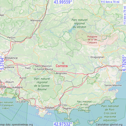
Correns GPS coordinates[2]
43° 29' 15.396" North, 6° 4' 46.272" East
| Map corner | latitude | longitude |
|---|---|---|
| Upper-left | 43.99559°, | 5.3764° |
| Center: | 43.48761°, | 6.07952° |
| Lower-right: | 42.97532°, | 6.78265° |
| Map W x H: | 113.4×113.4 km | = 70.5×70.5mi |
| max Lat: | 51.07786° ⇑93.2% North |
| Correns: | 43.48761° |
| min Lat: | ⇓6.8% South 41.3874° |
| min Long | Correns | max Long |
| -5.08615° | 6.07952° | 9.52242° |
| W 88%⇐ | ⇒12% E |
Elevation
Elevation of Correns is 170 m = 558 ft, and this is 23.7 m = 78 ft below average elevation for this country.
| Max E: |
2333 m = 7654 ft | 40% |
| Avg. | 193.7 m = 635 ft | |
| Correns | 170 m = 558 ft | |
Min E: |
-1 m = -3 ft | 60% |
See also: France elevation on elevation.city.
Geographical zone
Correns is located in North temperate zone (between Tropic of Cancer and the Arctic Circle). Distance of this Northern Tropic circle is 2229.4 km =1385.3 mi to South.| Distance of | km | miles | from Correns |
|---|---|---|---|
| North Pole | 5171.7 | 3213.5 | to North |
| Arctic Circle | 2565.8 | 1594.3 | to North |
| Tropic Cancer | 2229.4 | 1385.3 | to South |
| Equator | 4835.4 | 3004.6 | to South |


Nearby cities:
15 places around Correns: (largest is in red/bold)
• Barjols
9.7 km =6 mi,  323°
323°
• Bras
10.2 km =6.3 mi,  259°
259°
• Brignoles
9.2 km =5.7 mi,  188°
188°
• Brue-Auriac
12 km =7.5 mi,  292°
292°
• Cabasse
13.2 km =8.2 mi,  121°
121°
• Camps-la-Source
11.3 km =7 mi,  173°
173°
• Carcès
8.4 km =5.2 mi,  98°
98°
• Cotignac
7.3 km =4.5 mi,  50°
50°
• La Celle
10.8 km =6.7 mi,  198°
198°
• Le Val
5.4 km =3.4 mi, 185°
• Montfort-sur-Argens
3.6 km =2.2 mi, 116°
• Pontevès
8.4 km =5.2 mi,  331°
331°
• Sillans-la-Cascade
12 km =7.5 mi,  42°
42°
• Tavernes
12.8 km =8 mi,  336°
336°
• Vins-sur-Caramy
7.8 km =4.8 mi,  139°
139°
Sources, notices
• [Note1] Compared only with cities in France existing in our database
• [Src1] Map data: © OpenStreetMap contributors (CC-BY-SA)
• [Src2] Other city data from geonames.org with taken over terms of usage.
• [Src3] Geographical zone / Annual Mean Temperature by Robert A. Rohde @ Wikipedia
