Montesquiou geodata
Montesquiou (Occitanie) is a populated place; located in France in Europe/Paris (GMT+1) time zone. With population of 600 people, there are 13316 cities with bigger population in this country. Compared to other cities in France, 92.1% of cities are located further ↑North; 75.1% of cities are located further →East and 68.8% of cities have lower elevation than Montesquiou. Note1
Administrative division(s):
- Level 1: Occitanie
- Level 2: Gers
- Level 3: Arrondissement de Mirande
- Level 4: Montesquiou


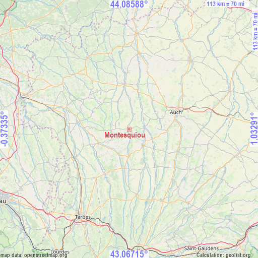
Montesquiou GPS coordinates[2]
43° 34' 43.212" North, 0° 19' 47.208" East
| Map corner | latitude | longitude |
|---|---|---|
| Upper-left | 44.08588°, | -0.37335° |
| Center: | 43.57867°, | 0.32978° |
| Lower-right: | 43.06715°, | 1.03291° |
| Map W x H: | 113.3×113.3 km | = 70.4×70.4mi |
| max Lat: | 51.07786° ⇑92.1% North |
| Montesquiou: | 43.57867° |
| min Lat: | ⇓7.9% South 41.3874° |
| min Long | Montesquiou | max Long |
| -5.08615° | 0.32978° | 9.52242° |
| W 24.9%⇐ | ⇒75.1% E |
Elevation
Elevation of Montesquiou is 213 m = 699 ft, and this is 19.3 m = 63 ft above average elevation for this country.
| Max E: |
2333 m = 7654 ft | 31.2% |
| Montesquiou | 213 m 699 ft | |
| Avg. | 193.7 m = 635 ft | |
Min E: |
-1 m = -3 ft | 68.8% |
See also: France elevation on elevation.city.
Geographical zone
Montesquiou is located in North temperate zone (between Tropic of Cancer and the Arctic Circle). Distance of this Northern Tropic circle is 2239.6 km =1391.6 mi to South.| Distance of | km | miles | from Montesquiou |
|---|---|---|---|
| North Pole | 5161.6 | 3207.3 | to North |
| Arctic Circle | 2555.7 | 1588 | to North |
| Tropic Cancer | 2239.6 | 1391.6 | to South |
| Equator | 4845.5 | 3010.9 | to South |


Nearby cities:
15 places around Montesquiou: (largest is in red/bold)
• Auch
22.1 km =13.7 mi,  70°
70°
• Auterive
22.9 km =14.2 mi,  88°
88°
• Barran
10.1 km =6.3 mi,  64°
64°
• Beaumarchés
19.9 km =12.4 mi,  271°
271°
• Duran
21.4 km =13.3 mi, 62°
• Jegun
23.6 km =14.7 mi,  27°
27°
• Marciac
14.9 km =9.3 mi,  245°
245°
• Mirande
9.3 km =5.8 mi,  139°
139°
• Miélan
16.6 km =10.3 mi,  186°
186°
• Ordan-Larroque
15.9 km =9.9 mi,  40°
40°
• Pavie
21.4 km =13.3 mi,  80°
80°
• Plaisance
23 km =14.3 mi,  277°
277°
• Seissan
23.3 km =14.5 mi,  114°
114°
• Vic-Fezensac
21.5 km =13.4 mi,  356°
356°
• Villecomtal-sur-Arros
22.5 km =14 mi,  207°
207°
Sources, notices
• [Note1] Compared only with cities in France existing in our database
• [Src1] Map data: © OpenStreetMap contributors (CC-BY-SA)
• [Src2] Other city data from geonames.org with taken over terms of usage.
• [Src3] Geographical zone / Annual Mean Temperature by Robert A. Rohde @ Wikipedia
