Jegun geodata
Jegun (Occitanie) is a populated place; located in France in Europe/Paris (GMT+2) time zone. With population of 1,063 people, there are 8380 cities with bigger population in this country. Compared to other cities in France, 89.5% of cities are located further ↑North; 73.7% of cities are located further →East and 51.4% of cities have higher elevation than Jegun. Note1


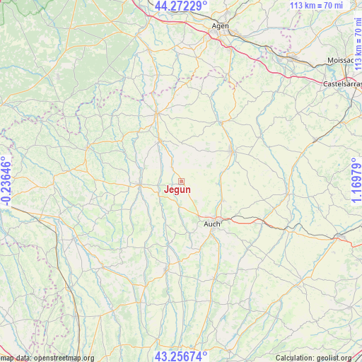
Jegun GPS coordinates[2]
43° 46' 0.012" North, 0° 28' 0.012" East
| Map corner | latitude | longitude |
|---|---|---|
| Upper-left | 44.27229°, | -0.23646° |
| Center: | 43.76667°, | 0.46667° |
| Lower-right: | 43.25674°, | 1.16979° |
| Map W x H: | 112.9×112.9 km | = 70.2×70.2mi |
| max Lat: | 51.07786° ⇑89.5% North |
| Jegun: | 43.76667° |
| min Lat: | ⇓10.5% South 41.3874° |
| min Long | Jegun | max Long |
| -5.08615° | 0.46667° | 9.52242° |
| W 26.3%⇐ | ⇒73.7% E |
Elevation
Elevation of Jegun is 127 m = 417 ft, and this is 66.7 m = 219 ft below average elevation for this country.
| Max E: |
2333 m = 7654 ft | 51.4% |
| Avg. | 193.7 m = 635 ft | |
| Jegun | 127 m = 417 ft | |
Min E: |
-1 m = -3 ft | 48.6% |
See also: France elevation on elevation.city.
Geographical zone
Jegun is located in North temperate zone (between Tropic of Cancer and the Arctic Circle). Distance of this Northern Tropic circle is 2260.5 km =1404.6 mi to South.| Distance of | km | miles | from Jegun |
|---|---|---|---|
| North Pole | 5140.7 | 3194.3 | to North |
| Arctic Circle | 2534.8 | 1575.1 | to North |
| Tropic Cancer | 2260.5 | 1404.6 | to South |
| Equator | 4866.4 | 3023.8 | to South |


Nearby cities:
15 places around Jegun: (largest is in red/bold)
• Auch
16.6 km =10.3 mi,  144°
144°
• Barran
16.7 km =10.4 mi,  186°
186°
• Castéra-Verduzan
5.2 km =3.2 mi,  326°
326°
• Caussens
19.9 km =12.4 mi,  350°
350°
• Duran
13.5 km =8.4 mi, 144°
• Fleurance
18.2 km =11.3 mi,  60°
60°
• Lannepax
19.5 km =12.1 mi,  281°
281°
• Montestruc-sur-Gers
13.4 km =8.3 mi,  77°
77°
• Ordan-Larroque
8.9 km =5.5 mi,  183°
183°
• Pauilhac
16.9 km =10.5 mi,  43°
43°
• Preignan
14.2 km =8.8 mi,  115°
115°
• Roquelaure
10.4 km =6.5 mi, 120°
• Saint-Puy
12.3 km =7.6 mi,  358°
358°
• Valence-sur-Baïse
14.6 km =9.1 mi, 331°
• Vic-Fezensac
12.3 km =7.6 mi,  272°
272°
Sources, notices
• [Note1] Compared only with cities in France existing in our database
• [Src1] Map data: © OpenStreetMap contributors (CC-BY-SA)
• [Src2] Other city data from geonames.org with taken over terms of usage.
• [Src3] Geographical zone / Annual Mean Temperature by Robert A. Rohde @ Wikipedia
