Seissan geodata
Seissan (Occitanie) is a populated place; located in France in Europe/Paris (GMT+2) time zone. With population of 1,048 people, there are 8479 cities with bigger population in this country. Compared to other cities in France, 93.2% of cities are located further ↑North; 72.4% of cities are located further →East and 64% of cities have lower elevation than Seissan. Note1
Administrative division(s):
- Level 1: Occitanie
- Level 2: Gers
- Level 3: Arrondissement de Mirande
- Level 4: Seissan


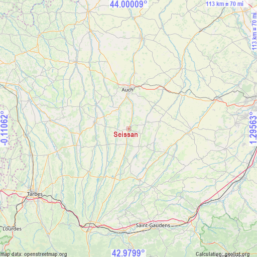
Seissan GPS coordinates[2]
43° 29' 31.74" North, 0° 35' 33" East
| Map corner | latitude | longitude |
|---|---|---|
| Upper-left | 44.00009°, | -0.11062° |
| Center: | 43.49215°, | 0.5925° |
| Lower-right: | 42.9799°, | 1.29563° |
| Map W x H: | 113.4×113.4 km | = 70.5×70.5mi |
| max Lat: | 51.07786° ⇑93.2% North |
| Seissan: | 43.49215° |
| min Lat: | ⇓6.8% South 41.3874° |
| min Long | Seissan | max Long |
| -5.08615° | 0.5925° | 9.52242° |
| W 27.6%⇐ | ⇒72.4% E |
Elevation
Elevation of Seissan is 189 m = 620 ft, and this is 4.7 m = 15 ft below average elevation for this country.
| Max E: |
2333 m = 7654 ft | 36% |
| Avg. | 193.7 m = 635 ft | |
| Seissan | 189 m = 620 ft | |
Min E: |
-1 m = -3 ft | 64% |
See also: France elevation on elevation.city.
Geographical zone
Seissan is located in North temperate zone (between Tropic of Cancer and the Arctic Circle). Distance of this Northern Tropic circle is 2230 km =1385.7 mi to South.| Distance of | km | miles | from Seissan |
|---|---|---|---|
| North Pole | 5171.2 | 3213.2 | to North |
| Arctic Circle | 2565.3 | 1594 | to North |
| Tropic Cancer | 2230 | 1385.7 | to South |
| Equator | 4835.9 | 3004.9 | to South |


Nearby cities:
15 places around Seissan: (largest is in red/bold)
• Aubiet
23.1 km =14.4 mi,  42°
42°
• Auch
17 km =10.6 mi,  358°
358°
• Auterive
10.2 km =6.3 mi,  9°
9°
• Barran
18.4 km =11.4 mi,  319°
319°
• Boulogne-sur-Gesse
21.9 km =13.6 mi,  167°
167°
• Castelnau-Magnoac
23.1 km =14.4 mi,  197°
197°
• Duran
19.7 km =12.2 mi,  353°
353°
• L’Isle-en-Dodon
23 km =14.3 mi,  121°
121°
• Masseube
7 km =4.3 mi,  189°
189°
• Mirande
15.4 km =9.6 mi,  279°
279°
• Montesquiou
23.3 km =14.5 mi,  294°
294°
• Pavie
13.1 km =8.1 mi, 359°
• Pessan
15 km =9.3 mi,  17°
17°
• Saramon
14.2 km =8.8 mi,  75°
75°
• Simorre
12.4 km =7.7 mi,  111°
111°
Sources, notices
• [Note1] Compared only with cities in France existing in our database
• [Src1] Map data: © OpenStreetMap contributors (CC-BY-SA)
• [Src2] Other city data from geonames.org with taken over terms of usage.
• [Src3] Geographical zone / Annual Mean Temperature by Robert A. Rohde @ Wikipedia
