Criquebeuf-sur-Seine geodata
Criquebeuf-sur-Seine (Normandy) is a populated place; located in France in Europe/Paris (GMT+2) time zone. With population of 1,085 people, there are 8226 cities with bigger population in this country. Compared to other cities in France, 86.2% of cities are located further ↓South; 67.9% of cities are located further →East and 97% of cities have higher elevation than Criquebeuf-sur-Seine. Note1
Administrative division(s):
- Level 1: Normandy
- Level 2: Département de l'Eure
- Level 3: Les Andelys
- Level 4: Criquebeuf-sur-Seine


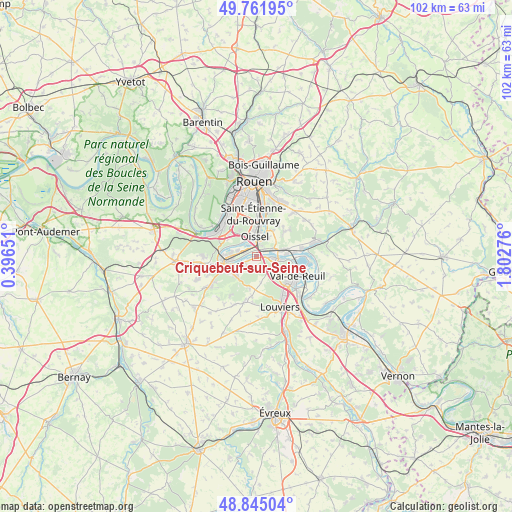
Criquebeuf-sur-Seine GPS coordinates[2]
49° 18' 20.268" North, 1° 5' 58.704" East
| Map corner | latitude | longitude |
|---|---|---|
| Upper-left | 49.76195°, | 0.39651° |
| Center: | 49.30563°, | 1.09964° |
| Lower-right: | 48.84504°, | 1.80276° |
| Map W x H: | 102×101.9 km | = 63.4×63.3mi |
| max Lat: | 51.07786° ⇑13.8% North |
| Criquebeuf-sur-Seine: | 49.30563° |
| min Lat: | ⇓86.2% South 41.3874° |
| min Long | Criquebeuf-sur- | max Long |
| -5.08615° | 1.09964° | 9.52242° |
| W 32.1%⇐ | ⇒67.9% E |
Elevation
Elevation of Criquebeuf-sur-Seine is 11 m = 36 ft, and this is 182.7 m = 599 ft below average elevation for this country.
| Max E: |
2333 m = 7654 ft | 97% |
| Avg. | 193.7 m = 635 ft | |
| Criquebeuf-sur-Seine | 11 m = 36 ft | |
Min E: |
-1 m = -3 ft | 3% |
See also: France elevation on elevation.city.
Geographical zone
Criquebeuf-sur-Seine is located in North temperate zone (between Tropic of Cancer and the Arctic Circle). Distance of this North polar circle is 1918.9 km =1192.3 mi to North.| Distance of | km | miles | from Criquebeuf-sur-Seine |
|---|---|---|---|
| North Pole | 4524.8 | 2811.6 | to North |
| Arctic Circle | 1918.9 | 1192.3 | to North |
| Tropic Cancer | 2876.4 | 1787.3 | to South |
| Equator | 5482.3 | 3406.5 | to South |


Nearby cities:
15 places around Criquebeuf-sur-Seine: (largest is in red/bold)
• Alizay
6 km =3.7 mi,  72°
72°
• Caudebec-lès-Elbeuf
6.3 km =3.9 mi,  243°
243°
• Cléon
5.1 km =3.2 mi,  278°
278°
• Elbeuf
7.3 km =4.5 mi,  253°
253°
• Freneuse
1.7 km =1.1 mi,  316°
316°
• Gouy
6.4 km =4 mi,  33°
33°
• Igoville
3.9 km =2.4 mi, 65°
• Les Authieux-sur-le-Port-Saint-Ouen
4.7 km =2.9 mi, 32°
• Les Damps
5.7 km =3.5 mi,  93°
93°
• Oissel
3.1 km =1.9 mi,  352°
352°
• Saint-Aubin-lès-Elbeuf
6.5 km =4 mi,  267°
267°
• Saint-Pierre-lès-Elbeuf
5.1 km =3.2 mi,  234°
234°
• Sotteville-sous-le-Val
2.3 km =1.4 mi,  49°
49°
• Tourville-la-Rivière
2.5 km =1.6 mi,  9°
9°
• Ymare
7.6 km =4.7 mi, 49°
Sources, notices
• [Note1] Compared only with cities in France existing in our database
• [Src1] Map data: © OpenStreetMap contributors (CC-BY-SA)
• [Src2] Other city data from geonames.org with taken over terms of usage.
• [Src3] Geographical zone / Annual Mean Temperature by Robert A. Rohde @ Wikipedia
