Montauban-de-Bretagne geodata
Montauban-de-Bretagne (Brittany) is a populated place; located in France in Europe/Paris (GMT+2) time zone. With population of 4,552 people, there are 2169 cities with bigger population in this country. Compared to other cities in France, 62.8% of cities are located further ↓South; 95% of cities are located further →East and 68.3% of cities have higher elevation than Montauban-de-Bretagne. Note1
Administrative division(s):
- Level 1: Brittany
- Level 2: Département d'Ille-et-Vilaine
- Level 3: Arrondissement de Rennes
- Level 4: Montauban-de-Bretagne
Current local time in Montauban-de-Bretagne:
04:41 AM, WednesdayDifference from your time zone: hours


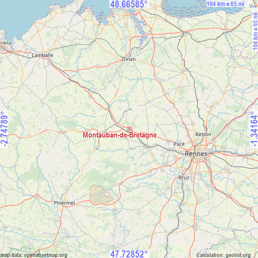
Montauban-de-Bretagne GPS coordinates[2]
48° 11' 57.588" North, 2° 2' 41.136" West
| Map corner | latitude | longitude |
|---|---|---|
| Upper-left | 48.66585°, | -2.74789° |
| Center: | 48.19933°, | -2.04476° |
| Lower-right: | 47.72852°, | -1.34164° |
| Map W x H: | 104.2×104.2 km | = 64.7×64.7mi |
| max Lat: | 51.07786° ⇑37.2% North |
| Montauban-de-Bretagne: | 48.19933° |
| min Lat: | ⇓62.8% South 41.3874° |
| min Long | Montauban-de-Br | max Long |
| -5.08615° | -2.04476° | 9.52242° |
| W 5%⇐ | ⇒95% E |
Elevation
Elevation of Montauban-de-Bretagne is 82 m = 269 ft, and this is 111.7 m = 366 ft below average elevation for this country.
| Max E: |
2333 m = 7654 ft | 68.3% |
| Avg. | 193.7 m = 635 ft | |
| Montauban-de-Bretagne | 82 m = 269 ft | |
Min E: |
-1 m = -3 ft | 31.7% |
See also: France elevation on elevation.city.
Geographical zone
Montauban-de-Bretagne is located in North temperate zone (between Tropic of Cancer and the Arctic Circle). Distance of this North polar circle is 2041.9 km =1268.8 mi to North.| Distance of | km | miles | from Montauban-de-Bretagne |
|---|---|---|---|
| North Pole | 4647.8 | 2888 | to North |
| Arctic Circle | 2041.9 | 1268.8 | to North |
| Tropic Cancer | 2753.3 | 1710.8 | to South |
| Equator | 5359.3 | 3330.1 | to South |


Nearby cities:
15 places around Montauban-de-Bretagne: (largest is in red/bold)
• Boisgervilly
3.9 km =2.4 mi,  201°
201°
• Bédée
7.7 km =4.8 mi,  106°
106°
• Guitté
11.4 km =7.1 mi,  341°
341°
• Iffendic
7.8 km =4.8 mi,  174°
174°
• Irodouër
9 km =5.6 mi,  51°
51°
• Landujan
6.8 km =4.2 mi,  32°
32°
• Montfort-sur-Meu
9.9 km =6.2 mi,  135°
135°
• Médréac
7.7 km =4.8 mi,  348°
348°
• Pleumeleuc
9.4 km =5.8 mi,  100°
100°
• Plouasne
11.6 km =7.2 mi,  13°
13°
• Quédillac
9.1 km =5.7 mi,  307°
307°
• Romillé
11.5 km =7.1 mi,  80°
80°
• Saint-Méen-le-Grand
11.2 km =7 mi,  264°
264°
• Saint-Onen-la-Chapelle
9.9 km =6.2 mi, 255°
• Saint-Pern
10.7 km =6.6 mi,  23°
23°
Sources, notices
• [Note1] Compared only with cities in France existing in our database
• [Src1] Map data: © OpenStreetMap contributors (CC-BY-SA)
• [Src2] Other city data from geonames.org with taken over terms of usage.
• [Src3] Geographical zone / Annual Mean Temperature by Robert A. Rohde @ Wikipedia
