Mons geodata
Mons (Occitanie) is a populated place; located in France in Europe/Paris (GMT+2) time zone. With population of 1,224 people, there are 7415 cities with bigger population in this country. Compared to other cities in France, 91.7% of cities are located further ↑North; 62.1% of cities are located further →East and 69.9% of cities have lower elevation than Mons. Note1
Administrative division(s):
- Level 1: Occitanie
- Level 2: Haute-Garonne
- Level 3: Arrondissement de Toulouse
- Level 4: Mons


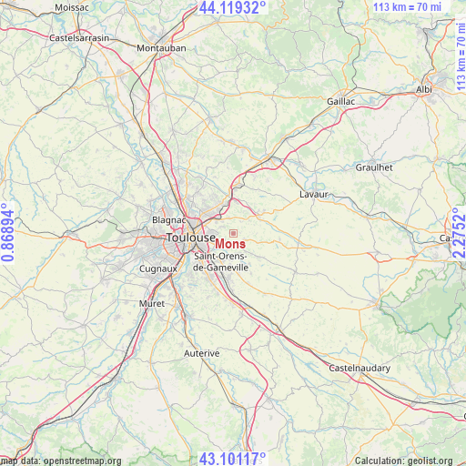
Mons GPS coordinates[2]
43° 36' 44.64" North, 1° 34' 19.452" East
| Map corner | latitude | longitude |
|---|---|---|
| Upper-left | 44.11932°, | 0.86894° |
| Center: | 43.6124°, | 1.57207° |
| Lower-right: | 43.10117°, | 2.2752° |
| Map W x H: | 113.2×113.2 km | = 70.3×70.3mi |
| max Lat: | 51.07786° ⇑91.7% North |
| Mons: | 43.6124° |
| min Lat: | ⇓8.3% South 41.3874° |
| min Long | Mons | max Long |
| -5.08615° | 1.57207° | 9.52242° |
| W 37.9%⇐ | ⇒62.1% E |
Elevation
Elevation of Mons is 219 m = 719 ft, and this is 25.3 m = 83 ft above average elevation for this country.
| Max E: |
2333 m = 7654 ft | 30.1% |
| Mons | 219 m 719 ft | |
| Avg. | 193.7 m = 635 ft | |
Min E: |
-1 m = -3 ft | 69.9% |
See also: France elevation on elevation.city.
Geographical zone
Mons is located in North temperate zone (between Tropic of Cancer and the Arctic Circle). Distance of this Northern Tropic circle is 2243.3 km =1393.9 mi to South.| Distance of | km | miles | from Mons |
|---|---|---|---|
| North Pole | 5157.8 | 3204.9 | to North |
| Arctic Circle | 2551.9 | 1585.7 | to North |
| Tropic Cancer | 2243.3 | 1393.9 | to South |
| Equator | 4849.2 | 3013.2 | to South |


Nearby cities:
15 places around Mons: (largest is in red/bold)
• Aigrefeuille
5.1 km =3.2 mi,  163°
163°
• Auzielle
7.9 km =4.9 mi,  183°
183°
• Balma
5.8 km =3.6 mi,  268°
268°
• Beaupuy
4.1 km =2.5 mi,  340°
340°
• Castelmaurou
7.9 km =4.9 mi, 336°
• Drémil-Lafage
3 km =1.9 mi,  127°
127°
• Flourens
2.3 km =1.4 mi,  199°
199°
• Gragnague
7.7 km =4.8 mi,  7°
7°
• Lauzerville
6.4 km =4 mi,  185°
185°
• Lavalette
3.4 km =2.1 mi,  34°
34°
• Montrabé
5.3 km =3.3 mi,  312°
312°
• Pin-Balma
3.6 km =2.2 mi,  299°
299°
• Rouffiac-Tolosan
7 km =4.3 mi,  327°
327°
• Saint-Jean
8.2 km =5.1 mi, 314°
• Saint-Orens-de-Gameville
7.2 km =4.5 mi,  205°
205°
Sources, notices
• [Note1] Compared only with cities in France existing in our database
• [Src1] Map data: © OpenStreetMap contributors (CC-BY-SA)
• [Src2] Other city data from geonames.org with taken over terms of usage.
• [Src3] Geographical zone / Annual Mean Temperature by Robert A. Rohde @ Wikipedia
