Drémil-Lafage geodata
Drémil-Lafage (Occitanie) is a populated place; located in France in Europe/Paris (GMT+2) time zone. With population of 2,894 people, there are 3366 cities with bigger population in this country. Compared to other cities in France, 91.9% of cities are located further ↑North; 61.7% of cities are located further →East and 65.8% of cities have lower elevation than Drémil-Lafage. Note1
Administrative division(s):
- Level 1: Occitanie
- Level 2: Haute-Garonne
- Level 3: Arrondissement de Toulouse
- Level 4: Drémil-Lafage


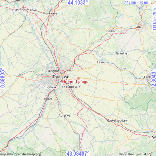
Drémil-Lafage GPS coordinates[2]
43° 35' 46.464" North, 1° 36' 4.212" East
| Map corner | latitude | longitude |
|---|---|---|
| Upper-left | 44.1033°, | 0.89805° |
| Center: | 43.59624°, | 1.60117° |
| Lower-right: | 43.08487°, | 2.3043° |
| Map W x H: | 113.2×113.2 km | = 70.3×70.3mi |
| max Lat: | 51.07786° ⇑91.9% North |
| Drémil-Lafage: | 43.59624° |
| min Lat: | ⇓8.1% South 41.3874° |
| min Long | Drémil-Lafage | max Long |
| -5.08615° | 1.60117° | 9.52242° |
| W 38.3%⇐ | ⇒61.7% E |
Elevation
Elevation of Drémil-Lafage is 198 m = 650 ft, and this is 4.3 m = 14 ft above average elevation for this country.
| Max E: |
2333 m = 7654 ft | 34.2% |
| Drémil-Lafage | 198 m 650 ft | |
| Avg. | 193.7 m = 635 ft | |
Min E: |
-1 m = -3 ft | 65.8% |
See also: France elevation on elevation.city.
Geographical zone
Drémil-Lafage is located in North temperate zone (between Tropic of Cancer and the Arctic Circle). Distance of this Northern Tropic circle is 2241.5 km =1392.8 mi to South.| Distance of | km | miles | from Drémil-Lafage |
|---|---|---|---|
| North Pole | 5159.6 | 3206 | to North |
| Arctic Circle | 2553.7 | 1586.8 | to North |
| Tropic Cancer | 2241.5 | 1392.8 | to South |
| Equator | 4847.4 | 3012 | to South |


Nearby cities:
15 places around Drémil-Lafage: (largest is in red/bold)
• Aigrefeuille
3.2 km =2 mi,  195°
195°
• Auzielle
6.7 km =4.2 mi,  205°
205°
• Balma
8.4 km =5.2 mi,  281°
281°
• Beaupuy
6.8 km =4.2 mi,  326°
326°
• Bourg-Saint-Bernard
8.9 km =5.5 mi,  87°
87°
• Flourens
3.1 km =1.9 mi,  262°
262°
• Lanta
6.2 km =3.9 mi,  121°
121°
• Lauzerville
5.4 km =3.4 mi, 212°
• Lavalette
4.6 km =2.9 mi,  354°
354°
• Mons
3 km =1.9 mi,  307°
307°
• Montrabé
8.2 km =5.1 mi, 310°
• Odars
8.2 km =5.1 mi,  186°
186°
• Pin-Balma
6.5 km =4 mi,  303°
303°
• Saint-Orens-de-Gameville
7.2 km =4.5 mi,  229°
229°
• Verfeil
8.5 km =5.3 mi,  36°
36°
Sources, notices
• [Note1] Compared only with cities in France existing in our database
• [Src1] Map data: © OpenStreetMap contributors (CC-BY-SA)
• [Src2] Other city data from geonames.org with taken over terms of usage.
• [Src3] Geographical zone / Annual Mean Temperature by Robert A. Rohde @ Wikipedia
