Flourens geodata
Flourens (Occitanie) is a populated place; located in France in Europe/Paris (GMT+2) time zone. With population of 1,703 people, there are 5514 cities with bigger population in this country. Compared to other cities in France, 91.9% of cities are located further ↑North; 62.2% of cities are located further →East and 71.2% of cities have lower elevation than Flourens. Note1
Administrative division(s):
- Level 1: Occitanie
- Level 2: Haute-Garonne
- Level 3: Arrondissement de Toulouse
- Level 4: Flourens


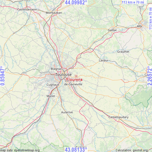
Flourens GPS coordinates[2]
43° 35' 33.828" North, 1° 33' 45.324" East
| Map corner | latitude | longitude |
|---|---|---|
| Upper-left | 44.09982°, | 0.85947° |
| Center: | 43.59273°, | 1.56259° |
| Lower-right: | 43.08133°, | 2.26572° |
| Map W x H: | 113.2×113.2 km | = 70.3×70.3mi |
| max Lat: | 51.07786° ⇑91.9% North |
| Flourens: | 43.59273° |
| min Lat: | ⇓8.1% South 41.3874° |
| min Long | Flourens | max Long |
| -5.08615° | 1.56259° | 9.52242° |
| W 37.8%⇐ | ⇒62.2% E |
Elevation
Elevation of Flourens is 225 m = 738 ft, and this is 31.3 m = 103 ft above average elevation for this country.
| Max E: |
2333 m = 7654 ft | 28.8% |
| Flourens | 225 m 738 ft | |
| Avg. | 193.7 m = 635 ft | |
Min E: |
-1 m = -3 ft | 71.2% |
See also: France elevation on elevation.city.
Geographical zone
Flourens is located in North temperate zone (between Tropic of Cancer and the Arctic Circle). Distance of this Northern Tropic circle is 2241.1 km =1392.6 mi to South.| Distance of | km | miles | from Flourens |
|---|---|---|---|
| North Pole | 5160 | 3206.3 | to North |
| Arctic Circle | 2554.1 | 1587 | to North |
| Tropic Cancer | 2241.1 | 1392.6 | to South |
| Equator | 4847.1 | 3011.8 | to South |


Nearby cities:
15 places around Flourens: (largest is in red/bold)
• Aigrefeuille
3.5 km =2.2 mi,  140°
140°
• Auzielle
5.7 km =3.5 mi,  177°
177°
• Balma
5.5 km =3.4 mi,  291°
291°
• Beaupuy
6.1 km =3.8 mi,  354°
354°
• Drémil-Lafage
3.1 km =1.9 mi,  82°
82°
• Escalquens
8.4 km =5.2 mi, 182°
• Labège
7.3 km =4.5 mi,  197°
197°
• Lauzerville
4.2 km =2.6 mi, 177°
• Lavalette
5.7 km =3.5 mi,  28°
28°
• Mons
2.3 km =1.4 mi,  19°
19°
• Montrabé
6.6 km =4.1 mi,  331°
331°
• Odars
8.1 km =5 mi,  164°
164°
• Pin-Balma
4.6 km =2.9 mi, 329°
• Rouffiac-Tolosan
8.7 km =5.4 mi,  339°
339°
• Saint-Orens-de-Gameville
4.9 km =3 mi,  208°
208°
Sources, notices
• [Note1] Compared only with cities in France existing in our database
• [Src1] Map data: © OpenStreetMap contributors (CC-BY-SA)
• [Src2] Other city data from geonames.org with taken over terms of usage.
• [Src3] Geographical zone / Annual Mean Temperature by Robert A. Rohde @ Wikipedia
