Mons geodata
Mons (Occitanie) is a populated place; located in France in Europe/Paris (GMT+2) time zone. With population of 576 people, there are 13727 cities with bigger population in this country. Compared to other cities in France, 92.2% of cities are located further ↑North; 57.2% of cities are located further ←West and 74.4% of cities have lower elevation than Mons. Note1
Administrative division(s):
- Level 1: Occitanie
- Level 2: Département de l'Hérault
- Level 3: Arrondissement de Béziers
- Level 4: Mons


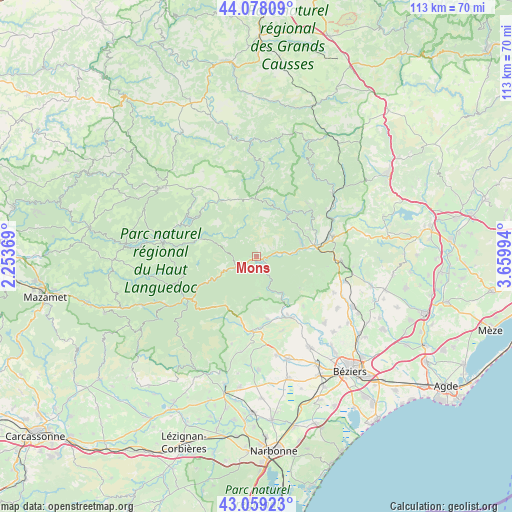
Mons GPS coordinates[2]
43° 34' 14.916" North, 2° 57' 24.552" East
| Map corner | latitude | longitude |
|---|---|---|
| Upper-left | 44.07809°, | 2.25369° |
| Center: | 43.57081°, | 2.95682° |
| Lower-right: | 43.05923°, | 3.65994° |
| Map W x H: | 113.3×113.3 km | = 70.4×70.4mi |
| max Lat: | 51.07786° ⇑92.2% North |
| Mons: | 43.57081° |
| min Lat: | ⇓7.8% South 41.3874° |
| min Long | Mons | max Long |
| -5.08615° | 2.95682° | 9.52242° |
| W 57.2%⇐ | ⇒42.8% E |
Elevation
Elevation of Mons is 245 m = 804 ft, and this is 51.3 m = 168 ft above average elevation for this country.
| Max E: |
2333 m = 7654 ft | 25.6% |
| Mons | 245 m 804 ft | |
| Avg. | 193.7 m = 635 ft | |
Min E: |
-1 m = -3 ft | 74.4% |
See also: France elevation on elevation.city.
Geographical zone
Mons is located in North temperate zone (between Tropic of Cancer and the Arctic Circle). Distance of this Northern Tropic circle is 2238.7 km =1391.1 mi to South.| Distance of | km | miles | from Mons |
|---|---|---|---|
| North Pole | 5162.4 | 3207.8 | to North |
| Arctic Circle | 2556.6 | 1588.6 | to North |
| Tropic Cancer | 2238.7 | 1391.1 | to South |
| Equator | 4844.6 | 3010.3 | to South |


Nearby cities:
15 places around Mons: (largest is in red/bold)
• Bédarieux
16.9 km =10.5 mi,  72°
72°
• Causses-et-Veyran
15 km =9.3 mi,  135°
135°
• Cessenon-sur-Orb
15.4 km =9.6 mi,  150°
150°
• Graissessac
16.4 km =10.2 mi,  43°
43°
• Hérépian
13.1 km =8.1 mi,  79°
79°
• La Tour-sur-Orb
18 km =11.2 mi,  60°
60°
• Lamalou-les-Bains
10.4 km =6.5 mi, 73°
• Le Poujol-sur-Orb
8.5 km =5.3 mi, 83°
• Les Aires
11.9 km =7.4 mi, 84°
• Murat-sur-Vèbre
15.1 km =9.4 mi,  327°
327°
• Olargues
3.7 km =2.3 mi,  245°
245°
• Riols
15.1 km =9.4 mi,  240°
240°
• Roquebrun
9.5 km =5.9 mi, 145°
• Saint-Chinian
16.5 km =10.3 mi,  182°
182°
• Saint-Gervais-sur-Mare
11.3 km =7 mi, 36°
Sources, notices
• [Note1] Compared only with cities in France existing in our database
• [Src1] Map data: © OpenStreetMap contributors (CC-BY-SA)
• [Src2] Other city data from geonames.org with taken over terms of usage.
• [Src3] Geographical zone / Annual Mean Temperature by Robert A. Rohde @ Wikipedia
