Causses-et-Veyran geodata
Causses-et-Veyran (Occitanie) is a populated place; located in France in Europe/Paris (GMT+2) time zone. With population of 619 people, there are 13004 cities with bigger population in this country. Compared to other cities in France, 93.4% of cities are located further ↑North; 59.1% of cities are located further ←West and 56.3% of cities have lower elevation than Causses-et-Veyran. Note1
Administrative division(s):
- Level 1: Occitanie
- Level 2: Département de l'Hérault
- Level 3: Arrondissement de Béziers
- Level 4: Causses-et-Veyran


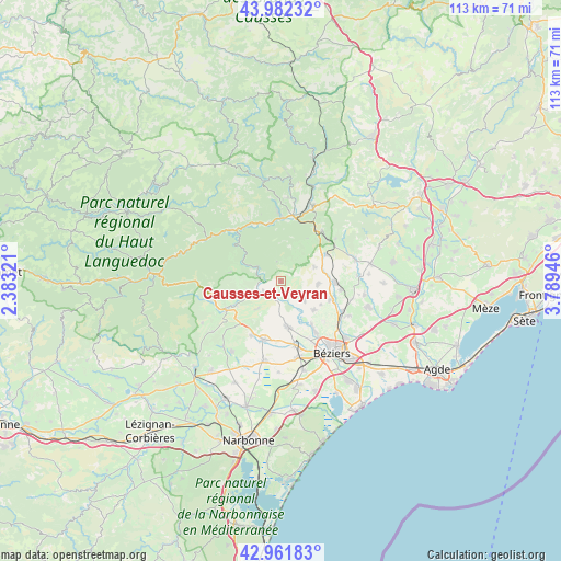
Causses-et-Veyran GPS coordinates[2]
43° 28' 27.228" North, 3° 5' 10.788" East
| Map corner | latitude | longitude |
|---|---|---|
| Upper-left | 43.98232°, | 2.38321° |
| Center: | 43.47423°, | 3.08633° |
| Lower-right: | 42.96183°, | 3.78946° |
| Map W x H: | 113.5×113.5 km | = 70.5×70.5mi |
| max Lat: | 51.07786° ⇑93.4% North |
| Causses-et-Veyran: | 43.47423° |
| min Lat: | ⇓6.6% South 41.3874° |
| min Long | Causses-et-Veyr | max Long |
| -5.08615° | 3.08633° | 9.52242° |
| W 59.1%⇐ | ⇒40.9% E |
Elevation
Elevation of Causses-et-Veyran is 155 m = 509 ft, and this is 38.7 m = 127 ft below average elevation for this country.
| Max E: |
2333 m = 7654 ft | 43.7% |
| Avg. | 193.7 m = 635 ft | |
| Causses-et-Veyran | 155 m = 509 ft | |
Min E: |
-1 m = -3 ft | 56.3% |
See also: France elevation on elevation.city.
Geographical zone
Causses-et-Veyran is located in North temperate zone (between Tropic of Cancer and the Arctic Circle). Distance of this Northern Tropic circle is 2228 km =1384.4 mi to South.| Distance of | km | miles | from Causses-et-Veyran |
|---|---|---|---|
| North Pole | 5173.2 | 3214.5 | to North |
| Arctic Circle | 2567.3 | 1595.2 | to North |
| Tropic Cancer | 2228 | 1384.4 | to South |
| Equator | 4833.9 | 3003.6 | to South |


Nearby cities:
15 places around Causses-et-Veyran: (largest is in red/bold)
• Autignac
7.2 km =4.5 mi,  67°
67°
• Cazouls-lès-Béziers
9.2 km =5.7 mi,  172°
172°
• Cessenon-sur-Orb
3.9 km =2.4 mi,  226°
226°
• Corneilhan
11.9 km =7.4 mi,  134°
134°
• Laurens
10.4 km =6.5 mi,  59°
59°
• Le Poujol-sur-Orb
11.8 km =7.3 mi,  350°
350°
• Les Aires
12 km =7.5 mi,  6°
6°
• Lignan-sur-Orb
12 km =7.5 mi,  146°
146°
• Magalas
11.1 km =6.9 mi,  91°
91°
• Murviel-lès-Béziers
5.9 km =3.7 mi,  140°
140°
• Pailhès
9.3 km =5.8 mi,  121°
121°
• Puimisson
10.4 km =6.5 mi,  112°
112°
• Roquebrun
5.8 km =3.6 mi,  299°
299°
• Saint-Geniès-de-Fontedit
7.9 km =4.9 mi,  96°
96°
• Thézan-lès-Béziers
9.1 km =5.7 mi, 134°
Sources, notices
• [Note1] Compared only with cities in France existing in our database
• [Src1] Map data: © OpenStreetMap contributors (CC-BY-SA)
• [Src2] Other city data from geonames.org with taken over terms of usage.
• [Src3] Geographical zone / Annual Mean Temperature by Robert A. Rohde @ Wikipedia
