Lamalou-les-Bains geodata
Lamalou-les-Bains (Occitanie) is a populated place; located in France in Europe/Paris (GMT+2) time zone. With population of 2,453 people, there are 3953 cities with bigger population in this country. Compared to other cities in France, 91.9% of cities are located further ↑North; 59% of cities are located further ←West and 64.2% of cities have lower elevation than Lamalou-les-Bains. Note1
Administrative division(s):
- Level 1: Occitanie
- Level 2: Département de l'Hérault
- Level 3: Arrondissement de Béziers
- Level 4: Lamalou-les-Bains


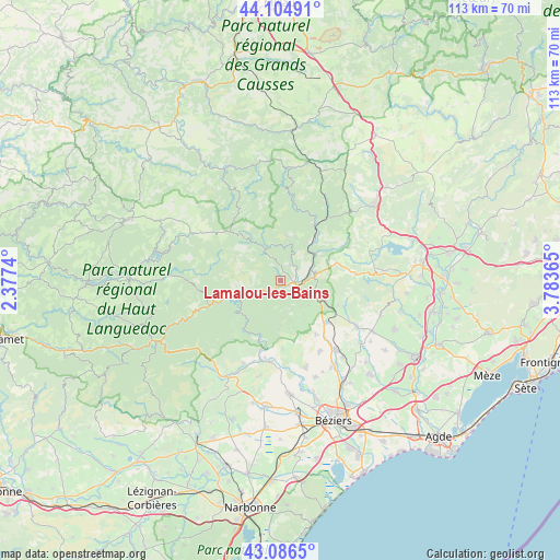
Lamalou-les-Bains GPS coordinates[2]
43° 35' 52.296" North, 3° 4' 49.872" East
| Map corner | latitude | longitude |
|---|---|---|
| Upper-left | 44.10491°, | 2.3774° |
| Center: | 43.59786°, | 3.08052° |
| Lower-right: | 43.0865°, | 3.78365° |
| Map W x H: | 113.2×113.2 km | = 70.3×70.3mi |
| max Lat: | 51.07786° ⇑91.9% North |
| Lamalou-les-Bains: | 43.59786° |
| min Lat: | ⇓8.1% South 41.3874° |
| min Long | Lamalou-les-Bai | max Long |
| -5.08615° | 3.08052° | 9.52242° |
| W 59%⇐ | ⇒41% E |
Elevation
Elevation of Lamalou-les-Bains is 190 m = 623 ft, and this is 3.7 m = 12 ft below average elevation for this country.
| Max E: |
2333 m = 7654 ft | 35.8% |
| Avg. | 193.7 m = 635 ft | |
| Lamalou-les-Bains | 190 m = 623 ft | |
Min E: |
-1 m = -3 ft | 64.2% |
See also: France elevation on elevation.city.
Geographical zone
Lamalou-les-Bains is located in North temperate zone (between Tropic of Cancer and the Arctic Circle). Distance of this Northern Tropic circle is 2241.7 km =1392.9 mi to South.| Distance of | km | miles | from Lamalou-les-Bains |
|---|---|---|---|
| North Pole | 5159.4 | 3205.9 | to North |
| Arctic Circle | 2553.5 | 1586.7 | to North |
| Tropic Cancer | 2241.7 | 1392.9 | to South |
| Equator | 4847.6 | 3012.2 | to South |


Nearby cities:
15 places around Lamalou-les-Bains: (largest is in red/bold)
• Autignac
13.1 km =8.1 mi,  146°
146°
• Bédarieux
6.5 km =4 mi,  72°
72°
• Causses-et-Veyran
13.8 km =8.6 mi,  178°
178°
• Graissessac
9 km =5.6 mi,  7°
7°
• Hérépian
2.9 km =1.8 mi,  100°
100°
• La Tour-sur-Orb
8.2 km =5.1 mi,  43°
43°
• Laurens
12.6 km =7.8 mi,  131°
131°
• Le Bousquet-d’Orb
12.6 km =7.8 mi,  33°
33°
• Le Poujol-sur-Orb
2.6 km =1.6 mi,  216°
216°
• Les Aires
2.6 km =1.6 mi, 134°
• Lunas
15.1 km =9.4 mi, 36°
• Mons
10.4 km =6.5 mi,  253°
253°
• Olargues
14.1 km =8.8 mi, 251°
• Roquebrun
11.8 km =7.3 mi,  202°
202°
• Saint-Gervais-sur-Mare
6.8 km =4.2 mi,  332°
332°
Sources, notices
• [Note1] Compared only with cities in France existing in our database
• [Src1] Map data: © OpenStreetMap contributors (CC-BY-SA)
• [Src2] Other city data from geonames.org with taken over terms of usage.
• [Src3] Geographical zone / Annual Mean Temperature by Robert A. Rohde @ Wikipedia
