Monchy-sur-Eu geodata
Monchy-sur-Eu (Normandy) is a populated place; located in France in Europe/Paris (GMT+2) time zone. With population of 507 people, there are 15105 cities with bigger population in this country. Compared to other cities in France, 93.5% of cities are located further ↓South; 63.6% of cities are located further →East and 58.3% of cities have higher elevation than Monchy-sur-Eu. Note1
Administrative division(s):
- Level 1: Normandy
- Level 2: Seine-Maritime
- Level 3: Arrondissement de Dieppe
- Level 4: Monchy-sur-Eu


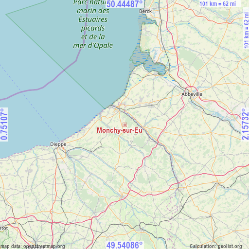
Monchy-sur-Eu GPS coordinates[2]
49° 59' 41.964" North, 1° 27' 15.12" East
| Map corner | latitude | longitude |
|---|---|---|
| Upper-left | 50.44487°, | 0.75107° |
| Center: | 49.99499°, | 1.4542° |
| Lower-right: | 49.54086°, | 2.15732° |
| Map W x H: | 100.5×100.5 km | = 62.4×62.4mi |
| max Lat: | 51.07786° ⇑6.5% North |
| Monchy-sur-Eu: | 49.99499° |
| min Lat: | ⇓93.5% South 41.3874° |
| min Long | Monchy-sur-Eu | max Long |
| -5.08615° | 1.4542° | 9.52242° |
| W 36.4%⇐ | ⇒63.6% E |
Elevation
Elevation of Monchy-sur-Eu is 107 m = 351 ft, and this is 86.7 m = 284 ft below average elevation for this country.
| Max E: |
2333 m = 7654 ft | 58.3% |
| Avg. | 193.7 m = 635 ft | |
| Monchy-sur-Eu | 107 m = 351 ft | |
Min E: |
-1 m = -3 ft | 41.7% |
See also: France elevation on elevation.city.
Geographical zone
Monchy-sur-Eu is located in North temperate zone (between Tropic of Cancer and the Arctic Circle). Distance of this North polar circle is 1842.3 km =1144.8 mi to North.| Distance of | km | miles | from Monchy-sur-Eu |
|---|---|---|---|
| North Pole | 4448.1 | 2763.9 | to North |
| Arctic Circle | 1842.3 | 1144.8 | to North |
| Tropic Cancer | 2953 | 1834.9 | to South |
| Equator | 5558.9 | 3454.1 | to South |


Nearby cities:
15 places around Monchy-sur-Eu: (largest is in red/bold)
• Beauchamps
4.9 km =3 mi,  67°
67°
• Bouvaincourt-sur-Bresle
4.7 km =2.9 mi,  34°
34°
• Béthencourt-sur-Mer
9.8 km =6.1 mi,  20°
20°
• Criel-sur-Mer
10.2 km =6.3 mi,  282°
282°
• Dargnies
7.2 km =4.5 mi,  44°
44°
• Embreville
7.3 km =4.5 mi,  59°
59°
• Eu
6.2 km =3.9 mi,  337°
337°
• Gamaches
7.4 km =4.6 mi,  97°
97°
• Incheville
3.5 km =2.2 mi, 56°
• Le Tréport
9.1 km =5.7 mi,  322°
322°
• Longroy
6.2 km =3.9 mi, 96°
• Mers-les-Bains
9.1 km =5.7 mi,  328°
328°
• Saint-Pierre-en-Val
3 km =1.9 mi,  350°
350°
• Woincourt
9.9 km =6.2 mi, 36°
• Yzengremer
8.8 km =5.5 mi, 33°
Sources, notices
• [Note1] Compared only with cities in France existing in our database
• [Src1] Map data: © OpenStreetMap contributors (CC-BY-SA)
• [Src2] Other city data from geonames.org with taken over terms of usage.
• [Src3] Geographical zone / Annual Mean Temperature by Robert A. Rohde @ Wikipedia
