Incheville geodata
Incheville (Normandy) is a populated place; located in France in Europe/Paris (GMT+2) time zone. With population of 1,475 people, there are 6277 cities with bigger population in this country. Compared to other cities in France, 93.6% of cities are located further ↓South; 63.1% of cities are located further →East and 89.9% of cities have higher elevation than Incheville. Note1
Administrative division(s):
- Level 1: Normandy
- Level 2: Seine-Maritime
- Level 3: Arrondissement de Dieppe
- Level 4: Incheville


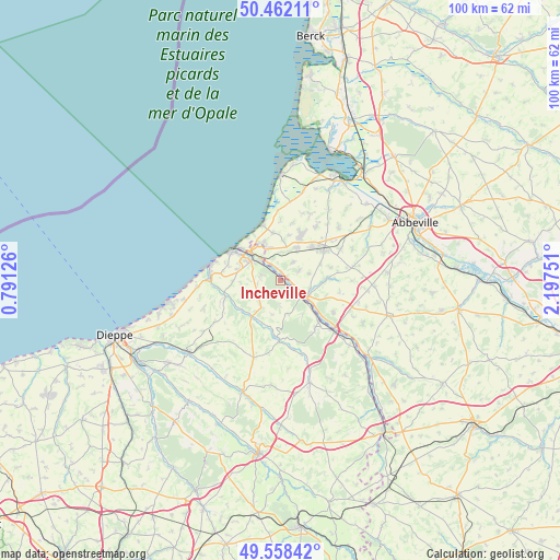
Incheville GPS coordinates[2]
50° 0' 44.604" North, 1° 29' 39.768" East
| Map corner | latitude | longitude |
|---|---|---|
| Upper-left | 50.46211°, | 0.79126° |
| Center: | 50.01239°, | 1.49438° |
| Lower-right: | 49.55842°, | 2.19751° |
| Map W x H: | 100.5×100.5 km | = 62.4×62.4mi |
| max Lat: | 51.07786° ⇑6.4% North |
| Incheville: | 50.01239° |
| min Lat: | ⇓93.6% South 41.3874° |
| min Long | Incheville | max Long |
| -5.08615° | 1.49438° | 9.52242° |
| W 36.9%⇐ | ⇒63.1% E |
Elevation
Elevation of Incheville is 30 m = 98 ft, and this is 163.7 m = 537 ft below average elevation for this country.
| Max E: |
2333 m = 7654 ft | 89.9% |
| Avg. | 193.7 m = 635 ft | |
| Incheville | 30 m = 98 ft | |
Min E: |
-1 m = -3 ft | 10.1% |
See also: France elevation on elevation.city.
Geographical zone
Incheville is located in North temperate zone (between Tropic of Cancer and the Arctic Circle). Distance of this North polar circle is 1840.3 km =1143.5 mi to North.| Distance of | km | miles | from Incheville |
|---|---|---|---|
| North Pole | 4446.2 | 2762.7 | to North |
| Arctic Circle | 1840.3 | 1143.5 | to North |
| Tropic Cancer | 2954.9 | 1836.1 | to South |
| Equator | 5560.9 | 3455.4 | to South |


Nearby cities:
15 places around Incheville: (largest is in red/bold)
• Beauchamps
1.7 km =1.1 mi,  91°
91°
• Bouvaincourt-sur-Bresle
2 km =1.2 mi,  354°
354°
• Béthencourt-sur-Mer
7.3 km =4.5 mi,  5°
5°
• Dargnies
3.9 km =2.4 mi,  34°
34°
• Embreville
3.8 km =2.4 mi,  61°
61°
• Eu
6.5 km =4 mi,  305°
305°
• Fressenneville
8.6 km =5.3 mi,  43°
43°
• Friaucourt
8.6 km =5.3 mi, 351°
• Gamaches
5.3 km =3.3 mi,  123°
123°
• Longroy
4.2 km =2.6 mi,  128°
128°
• Monchy-sur-Eu
3.5 km =2.2 mi,  236°
236°
• Saint-Pierre-en-Val
3.5 km =2.2 mi,  286°
286°
• Tully
8.3 km =5.2 mi, 11°
• Woincourt
6.7 km =4.2 mi, 26°
• Yzengremer
5.8 km =3.6 mi,  20°
20°
Sources, notices
• [Note1] Compared only with cities in France existing in our database
• [Src1] Map data: © OpenStreetMap contributors (CC-BY-SA)
• [Src2] Other city data from geonames.org with taken over terms of usage.
• [Src3] Geographical zone / Annual Mean Temperature by Robert A. Rohde @ Wikipedia
