Mezel geodata
Mezel (Auvergne-Rhône-Alpes) is a populated place; located in France in Europe/Paris (GMT+2) time zone. With population of 1,560 people, there are 5972 cities with bigger population in this country. Compared to other cities in France, 70% of cities are located further ↑North; 61.2% of cities are located further ←West and 87.6% of cities have lower elevation than Mezel. Note1
Administrative division(s):
- Level 1: Auvergne-Rhône-Alpes
- Level 2: Département du Puy-de-Dôme
- Level 3: Arrondissement de Clermont-Ferrand
- Level 4: Mur-sur-Allier


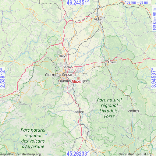
Mezel GPS coordinates[2]
45° 45' 18.288" North, 3° 14' 32.1" East
| Map corner | latitude | longitude |
|---|---|---|
| Upper-left | 46.24351°, | 2.53912° |
| Center: | 45.75508°, | 3.24225° |
| Lower-right: | 45.26233°, | 3.94537° |
| Map W x H: | 109.1×109.1 km | = 67.8×67.8mi |
| max Lat: | 51.07786° ⇑70% North |
| Mezel: | 45.75508° |
| min Lat: | ⇓30% South 41.3874° |
| min Long | Mezel | max Long |
| -5.08615° | 3.24225° | 9.52242° |
| W 61.2%⇐ | ⇒38.8% E |
Elevation
Elevation of Mezel is 382 m = 1253 ft, and this is 188.3 m = 618 ft above average elevation for this country.
| Max E: |
2333 m = 7654 ft | 12.4% |
| Mezel | 382 m 1253 ft | |
| Avg. | 193.7 m = 635 ft | |
Min E: |
-1 m = -3 ft | 87.6% |
See also: France elevation on elevation.city.
Geographical zone
Mezel is located in North temperate zone (between Tropic of Cancer and the Arctic Circle). Distance of this North polar circle is 2313.7 km =1437.7 mi to North.| Distance of | km | miles | from Mezel |
|---|---|---|---|
| North Pole | 4919.6 | 3056.9 | to North |
| Arctic Circle | 2313.7 | 1437.7 | to North |
| Tropic Cancer | 2481.6 | 1542 | to South |
| Equator | 5087.5 | 3161.2 | to South |


Nearby cities:
15 places around Mezel: (largest is in red/bold)
• Aulnat
7.6 km =4.7 mi,  310°
310°
• Billom
8.3 km =5.2 mi,  115°
115°
• Bouzel
6.3 km =3.9 mi,  67°
67°
• Chauriat
2.9 km =1.8 mi,  98°
98°
• Cournon-d’Auvergne
3.9 km =2.4 mi,  246°
246°
• Dallet
1.7 km =1.1 mi,  350°
350°
• Le Cendre
5.6 km =3.5 mi,  229°
229°
• Malintrat
8 km =5 mi,  326°
326°
• Mirefleurs
7 km =4.3 mi,  191°
191°
• Orcet
8.1 km =5 mi,  224°
224°
• Pont-du-Château
4.8 km =3 mi,  5°
5°
• Pérignat-lès-Sarliève
8.2 km =5.1 mi,  255°
255°
• Pérignat-sur-Allier
3.1 km =1.9 mi,  195°
195°
• Saint-Georges-sur-Allier
5 km =3.1 mi,  179°
179°
• Vertaizon
3.8 km =2.4 mi,  64°
64°
Sources, notices
• [Note1] Compared only with cities in France existing in our database
• [Src1] Map data: © OpenStreetMap contributors (CC-BY-SA)
• [Src2] Other city data from geonames.org with taken over terms of usage.
• [Src3] Geographical zone / Annual Mean Temperature by Robert A. Rohde @ Wikipedia
