Orcet geodata
Orcet (Auvergne-Rhône-Alpes) is a populated place; located in France in Europe/Paris (GMT+2) time zone. With population of 2,802 people, there are 3482 cities with bigger population in this country. Compared to other cities in France, 70.9% of cities are located further ↑North; 60.2% of cities are located further ←West and 88.2% of cities have lower elevation than Orcet. Note1
Administrative division(s):
- Level 1: Auvergne-Rhône-Alpes
- Level 2: Département du Puy-de-Dôme
- Level 3: Arrondissement de Clermont-Ferrand
- Level 4: Orcet


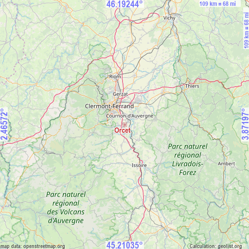
Orcet GPS coordinates[2]
45° 42' 12.78" North, 3° 10' 7.824" East
| Map corner | latitude | longitude |
|---|---|---|
| Upper-left | 46.19244°, | 2.46572° |
| Center: | 45.70355°, | 3.16884° |
| Lower-right: | 45.21035°, | 3.87197° |
| Map W x H: | 109.2×109.2 km | = 67.9×67.9mi |
| max Lat: | 51.07786° ⇑70.9% North |
| Orcet: | 45.70355° |
| min Lat: | ⇓29.1% South 41.3874° |
| min Long | Orcet | max Long |
| -5.08615° | 3.16884° | 9.52242° |
| W 60.2%⇐ | ⇒39.8% E |
Elevation
Elevation of Orcet is 391 m = 1283 ft, and this is 197.3 m = 647 ft above average elevation for this country.
| Max E: |
2333 m = 7654 ft | 11.8% |
| Orcet | 391 m 1283 ft | |
| Avg. | 193.7 m = 635 ft | |
Min E: |
-1 m = -3 ft | 88.2% |
See also: France elevation on elevation.city.
Geographical zone
Orcet is located in North temperate zone (between Tropic of Cancer and the Arctic Circle). Distance of this North polar circle is 2319.4 km =1441.2 mi to North.| Distance of | km | miles | from Orcet |
|---|---|---|---|
| North Pole | 4925.3 | 3060.4 | to North |
| Arctic Circle | 2319.4 | 1441.2 | to North |
| Tropic Cancer | 2475.8 | 1538.4 | to South |
| Equator | 5081.8 | 3157.7 | to South |


Nearby cities:
15 places around Orcet: (largest is in red/bold)
• Chanonat
6 km =3.7 mi,  258°
258°
• Corent
4.5 km =2.8 mi,  153°
153°
• Cournon-d’Auvergne
4.7 km =2.9 mi,  27°
27°
• La Roche-Blanche
3.3 km =2.1 mi, 264°
• Le Cendre
2.5 km =1.6 mi, 34°
• Le Crest
3.7 km =2.3 mi,  239°
239°
• Mirefleurs
4.4 km =2.7 mi,  105°
105°
• Pérignat-lès-Sarliève
4.3 km =2.7 mi,  328°
328°
• Pérignat-sur-Allier
5.6 km =3.5 mi,  60°
60°
• Romagnat
6 km =3.7 mi,  298°
298°
• Saint-Amant-Tallende
6.1 km =3.8 mi,  230°
230°
• Saint-Georges-sur-Allier
5.8 km =3.6 mi,  82°
82°
• Saint-Maurice
6.4 km =4 mi,  124°
124°
• Tallende
5 km =3.1 mi,  222°
222°
• Veyre-Monton
3.9 km =2.4 mi,  177°
177°
Sources, notices
• [Note1] Compared only with cities in France existing in our database
• [Src1] Map data: © OpenStreetMap contributors (CC-BY-SA)
• [Src2] Other city data from geonames.org with taken over terms of usage.
• [Src3] Geographical zone / Annual Mean Temperature by Robert A. Rohde @ Wikipedia
