Meyzieu geodata
Meyzieu (Auvergne-Rhône-Alpes) is a populated place; located in France in Europe/Paris (GMT+2) time zone. With population of 28,929 people, there are 290 cities with bigger population in this country. Compared to other cities in France, 69.8% of cities are located further ↑North; 77.7% of cities are located further ←West and 68.1% of cities have lower elevation than Meyzieu. Note1
Administrative division(s):
- Level 1: Auvergne-Rhône-Alpes
- Level 2: Département du Rhône
- Level 3: Arrondissement de Lyon
- Level 4: Meyzieu


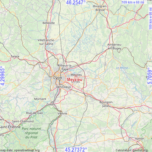
Meyzieu GPS coordinates[2]
45° 45' 58.932" North, 5° 0' 9.972" East
| Map corner | latitude | longitude |
|---|---|---|
| Upper-left | 46.2547°, | 4.29965° |
| Center: | 45.76637°, | 5.00277° |
| Lower-right: | 45.27372°, | 5.7059° |
| Map W x H: | 109.1×109.1 km | = 67.8×67.8mi |
| max Lat: | 51.07786° ⇑69.8% North |
| Meyzieu: | 45.76637° |
| min Lat: | ⇓30.2% South 41.3874° |
| min Long | Meyzieu | max Long |
| -5.08615° | 5.00277° | 9.52242° |
| W 77.7%⇐ | ⇒22.3% E |
Elevation
Elevation of Meyzieu is 210 m = 689 ft, and this is 16.3 m = 53 ft above average elevation for this country.
| Max E: |
2333 m = 7654 ft | 31.9% |
| Meyzieu | 210 m 689 ft | |
| Avg. | 193.7 m = 635 ft | |
Min E: |
-1 m = -3 ft | 68.1% |
See also: France elevation on elevation.city.
Geographical zone
Meyzieu is located in North temperate zone (between Tropic of Cancer and the Arctic Circle). Distance of this North polar circle is 2312.4 km =1436.9 mi to North.| Distance of | km | miles | from Meyzieu |
|---|---|---|---|
| North Pole | 4918.3 | 3056.1 | to North |
| Arctic Circle | 2312.4 | 1436.9 | to North |
| Tropic Cancer | 2482.8 | 1542.7 | to South |
| Equator | 5088.7 | 3162 | to South |


Nearby cities:
15 places around Meyzieu: (largest is in red/bold)
• Beynost
7.7 km =4.8 mi,  357°
357°
• Bron
7.6 km =4.7 mi,  246°
246°
• Chassieu
3.4 km =2.1 mi,  227°
227°
• Décines-Charpieu
3.4 km =2.1 mi,  274°
274°
• Genas
3.9 km =2.4 mi,  180°
180°
• Janneyrias
8.7 km =5.4 mi,  100°
100°
• Jonage
4.8 km =3 mi,  45°
45°
• Jons
7.6 km =4.7 mi, 52°
• Miribel
7.6 km =4.7 mi,  330°
330°
• Niévroz
8 km =5 mi,  34°
34°
• Pusignan
5.1 km =3.2 mi, 103°
• Saint-Bonnet-de-Mure
8.7 km =5.4 mi,  166°
166°
• Saint-Maurice-de-Beynost
7.8 km =4.8 mi,  345°
345°
• Thil
5.5 km =3.4 mi,  16°
16°
• Vaulx-en-Velin
6.4 km =4 mi,  290°
290°
Sources, notices
• [Note1] Compared only with cities in France existing in our database
• [Src1] Map data: © OpenStreetMap contributors (CC-BY-SA)
• [Src2] Other city data from geonames.org with taken over terms of usage.
• [Src3] Geographical zone / Annual Mean Temperature by Robert A. Rohde @ Wikipedia
