Jons geodata
Jons (Auvergne-Rhône-Alpes) is a populated place; located in France in Europe/Paris (GMT+2) time zone. With population of 1,235 people, there are 7355 cities with bigger population in this country. Compared to other cities in France, 69.1% of cities are located further ↑North; 78.5% of cities are located further ←West and 70.6% of cities have lower elevation than Jons. Note1
Administrative division(s):
- Level 1: Auvergne-Rhône-Alpes
- Level 2: Département du Rhône
- Level 3: Arrondissement de Lyon
- Level 4: Jons


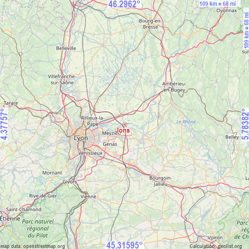
Jons GPS coordinates[2]
45° 48' 29.628" North, 5° 4' 50.52" East
| Map corner | latitude | longitude |
|---|---|---|
| Upper-left | 46.2962°, | 4.37757° |
| Center: | 45.80823°, | 5.0807° |
| Lower-right: | 45.31595°, | 5.78382° |
| Map W x H: | 109×109 km | = 67.7×67.7mi |
| max Lat: | 51.07786° ⇑69.1% North |
| Jons: | 45.80823° |
| min Lat: | ⇓30.9% South 41.3874° |
| min Long | Jons | max Long |
| -5.08615° | 5.0807° | 9.52242° |
| W 78.5%⇐ | ⇒21.5% E |
Elevation
Elevation of Jons is 222 m = 728 ft, and this is 28.3 m = 93 ft above average elevation for this country.
| Max E: |
2333 m = 7654 ft | 29.4% |
| Jons | 222 m 728 ft | |
| Avg. | 193.7 m = 635 ft | |
Min E: |
-1 m = -3 ft | 70.6% |
See also: France elevation on elevation.city.
Geographical zone
Jons is located in North temperate zone (between Tropic of Cancer and the Arctic Circle). Distance of this North polar circle is 2307.8 km =1434 mi to North.| Distance of | km | miles | from Jons |
|---|---|---|---|
| North Pole | 4913.7 | 3053.2 | to North |
| Arctic Circle | 2307.8 | 1434 | to North |
| Tropic Cancer | 2487.5 | 1545.7 | to South |
| Equator | 5093.4 | 3164.9 | to South |


Nearby cities:
15 places around Jons: (largest is in red/bold)
• Anthon
7.2 km =4.5 mi,  105°
105°
• Balan
3.2 km =2 mi,  26°
26°
• Beynost
7 km =4.3 mi,  295°
295°
• Bressolles
6.7 km =4.2 mi,  10°
10°
• Béligneux
7.5 km =4.7 mi, 28°
• Charvieu-Chavagneux
8.4 km =5.2 mi,  140°
140°
• Dagneux
4.8 km =3 mi,  357°
357°
• Janneyrias
6.7 km =4.2 mi,  158°
158°
• Jonage
3 km =1.9 mi,  243°
243°
• La Boisse
5.2 km =3.2 mi,  318°
318°
• Meyzieu
7.6 km =4.7 mi,  232°
232°
• Montluel
5.2 km =3.2 mi,  339°
339°
• Niévroz
2.5 km =1.6 mi, 322°
• Pusignan
5.9 km =3.7 mi,  190°
190°
• Thil
4.5 km =2.8 mi,  277°
277°
Sources, notices
• [Note1] Compared only with cities in France existing in our database
• [Src1] Map data: © OpenStreetMap contributors (CC-BY-SA)
• [Src2] Other city data from geonames.org with taken over terms of usage.
• [Src3] Geographical zone / Annual Mean Temperature by Robert A. Rohde @ Wikipedia
