Saint-Ouen-les-Vignes geodata
Saint-Ouen-les-Vignes (Centre) is a populated place; located in France in Europe/Paris (GMT+2) time zone. With population of 990 people, there are 8905 cities with bigger population in this country. Compared to other cities in France, 50.7% of cities are located further ↓South; 68.8% of cities are located further →East and 69.2% of cities have higher elevation than Saint-Ouen-les-Vignes. Note1
Administrative division(s):
- Level 1: Centre
- Level 2: Département d'Indre-et-Loire
- Level 3: Arrondissement de Loches
- Level 4: Saint-Ouen-les-Vignes
Current local time in Saint-Ouen-les-Vignes:
09:34 AM, SaturdayDifference from your time zone: hours


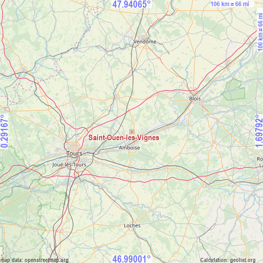
Saint-Ouen-les-Vignes GPS coordinates[2]
47° 28' 2.928" North, 0° 59' 41.244" East
| Map corner | latitude | longitude |
|---|---|---|
| Upper-left | 47.94065°, | 0.29167° |
| Center: | 47.46748°, | 0.99479° |
| Lower-right: | 46.99001°, | 1.69792° |
| Map W x H: | 105.7×105.7 km | = 65.7×65.7mi |
| max Lat: | 51.07786° ⇑49.3% North |
| Saint-Ouen-les-Vignes: | 47.46748° |
| min Lat: | ⇓50.7% South 41.3874° |
| min Long | Saint-Ouen-les- | max Long |
| -5.08615° | 0.99479° | 9.52242° |
| W 31.2%⇐ | ⇒68.8% E |
Elevation
Elevation of Saint-Ouen-les-Vignes is 80 m = 262 ft, and this is 113.7 m = 373 ft below average elevation for this country.
| Max E: |
2333 m = 7654 ft | 69.2% |
| Avg. | 193.7 m = 635 ft | |
| Saint-Ouen-les-Vignes | 80 m = 262 ft | |
Min E: |
-1 m = -3 ft | 30.8% |
See also: France elevation on elevation.city.
Geographical zone
Saint-Ouen-les-Vignes is located in North temperate zone (between Tropic of Cancer and the Arctic Circle). Distance of this North polar circle is 2123.3 km =1319.4 mi to North.| Distance of | km | miles | from Saint-Ouen-les-Vignes |
|---|---|---|---|
| North Pole | 4729.2 | 2938.6 | to North |
| Arctic Circle | 2123.3 | 1319.4 | to North |
| Tropic Cancer | 2672 | 1660.3 | to South |
| Equator | 5277.9 | 3279.5 | to South |


Nearby cities:
15 places around Saint-Ouen-les-Vignes: (largest is in red/bold)
• Amboise
6.2 km =3.9 mi,  188°
188°
• Auzouer-en-Touraine
10 km =6.2 mi,  326°
326°
• Cangey
4.9 km =3 mi,  90°
90°
• Chançay
9.2 km =5.7 mi,  260°
260°
• Chargé
4.7 km =2.9 mi,  145°
145°
• Limeray
3.5 km =2.2 mi,  104°
104°
• Lussault-sur-Loire
10 km =6.2 mi,  216°
216°
• Monteaux
9.2 km =5.7 mi,  75°
75°
• Montreuil-en-Touraine
4.1 km =2.5 mi,  303°
303°
• Mosnes
8 km =5 mi, 99°
• Nazelles-Négron
5.1 km =3.2 mi, 221°
• Neuillé-le-Lierre
8 km =5 mi,  307°
307°
• Noizay
9.2 km =5.7 mi,  236°
236°
• Pocé-sur-Cisse
2.7 km =1.7 mi, 185°
• Reugny
8.4 km =5.2 mi,  281°
281°
Sources, notices
• [Note1] Compared only with cities in France existing in our database
• [Src1] Map data: © OpenStreetMap contributors (CC-BY-SA)
• [Src2] Other city data from geonames.org with taken over terms of usage.
• [Src3] Geographical zone / Annual Mean Temperature by Robert A. Rohde @ Wikipedia
