Merville-Franceville-Plage geodata
Merville-Franceville-Plage (Normandy) is a populated place; located in France in Europe/Paris (GMT+2) time zone. With population of 1,592 people, there are 5857 cities with bigger population in this country. Compared to other cities in France, 85.5% of cities are located further ↓South; 79.6% of cities are located further →East and 96.7% of cities have higher elevation than Merville-Franceville-Plage. Note1
Administrative division(s):
- Level 1: Normandy
- Level 2: Calvados
- Level 3: Arrondissement de Lisieux
- Level 4: Merville-Franceville-Plage
Current local time in Merville-Franceville-Plage:
06:01 AM, WednesdayDifference from your time zone: hours


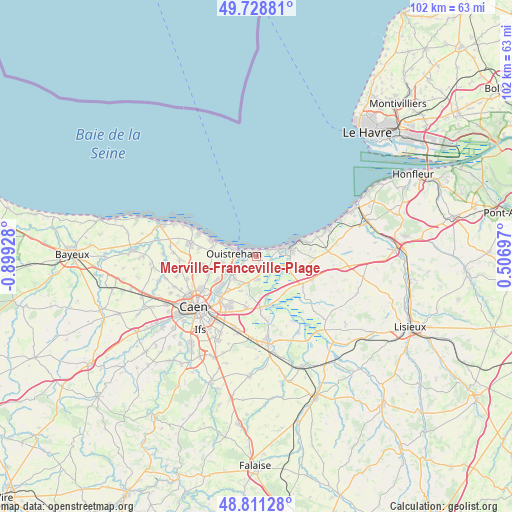
Merville-Franceville-Plage GPS coordinates[2]
49° 16' 19.848" North, 0° 11' 46.176" West
| Map corner | latitude | longitude |
|---|---|---|
| Upper-left | 49.72881°, | -0.89928° |
| Center: | 49.27218°, | -0.19616° |
| Lower-right: | 48.81128°, | 0.50697° |
| Map W x H: | 102×102 km | = 63.4×63.4mi |
| max Lat: | 51.07786° ⇑14.5% North |
| Merville-Franceville-Plage: | 49.27218° |
| min Lat: | ⇓85.5% South 41.3874° |
| min Long | Merville-France | max Long |
| -5.08615° | -0.19616° | 9.52242° |
| W 20.4%⇐ | ⇒79.6% E |
Elevation
Elevation of Merville-Franceville-Plage is 12 m = 39 ft, and this is 181.7 m = 596 ft below average elevation for this country.
| Max E: |
2333 m = 7654 ft | 96.7% |
| Avg. | 193.7 m = 635 ft | |
| Merville-Franceville-Plage | 12 m = 39 ft | |
Min E: |
-1 m = -3 ft | 3.3% |
See also: France elevation on elevation.city.
Geographical zone
Merville-Franceville-Plage is located in North temperate zone (between Tropic of Cancer and the Arctic Circle). Distance of this North polar circle is 1922.6 km =1194.6 mi to North.| Distance of | km | miles | from Merville-Franceville-Plage |
|---|---|---|---|
| North Pole | 4528.5 | 2813.9 | to North |
| Arctic Circle | 1922.6 | 1194.6 | to North |
| Tropic Cancer | 2872.6 | 1785 | to South |
| Equator | 5478.6 | 3404.2 | to South |


Nearby cities:
15 places around Merville-Franceville-Plage: (largest is in red/bold)
• Amfreville
3.7 km =2.3 mi,  227°
227°
• Bavent
4.7 km =2.9 mi,  171°
171°
• Blainville-sur-Orne
9 km =5.6 mi,  237°
237°
• Bréville-les-Monts
5.1 km =3.2 mi,  211°
211°
• Bénouville
7.1 km =4.4 mi, 241°
• Cabourg
6.4 km =4 mi,  70°
70°
• Colleville-Montgomery
7.6 km =4.7 mi,  272°
272°
• Dives-sur-Mer
7 km =4.3 mi,  81°
81°
• Escoville
7.6 km =4.7 mi,  204°
204°
• Hermanville-sur-Mer
8.8 km =5.5 mi,  279°
279°
• Houlgate
8.8 km =5.5 mi, 70°
• Hérouvillette
6.6 km =4.1 mi, 211°
• Ouistreham
4.6 km =2.9 mi, 274°
• Ranville
6.3 km =3.9 mi,  223°
223°
• Varaville
3.4 km =2.1 mi,  127°
127°
Sources, notices
• [Note1] Compared only with cities in France existing in our database
• [Src1] Map data: © OpenStreetMap contributors (CC-BY-SA)
• [Src2] Other city data from geonames.org with taken over terms of usage.
• [Src3] Geographical zone / Annual Mean Temperature by Robert A. Rohde @ Wikipedia
