Menomblet geodata
Menomblet (Pays de la Loire) is a populated place; located in France in Europe/Paris (GMT+2) time zone. With population of 701 people, there are 11792 cities with bigger population in this country. Compared to other cities in France, 57.9% of cities are located further ↑North; 85.7% of cities are located further →East and 66.4% of cities have lower elevation than Menomblet. Note1
Administrative division(s):
- Level 1: Pays de la Loire
- Level 2: Département de la Vendée
- Level 3: Arrondissement de Fontenay-le-Comte
- Level 4: Menomblet


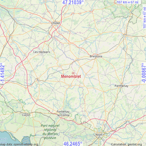
Menomblet GPS coordinates[2]
46° 43' 50.16" North, 0° 42' 42.444" West
| Map corner | latitude | longitude |
|---|---|---|
| Upper-left | 47.21039°, | -1.41492° |
| Center: | 46.7306°, | -0.71179° |
| Lower-right: | 46.2465°, | -0.00867° |
| Map W x H: | 107.2×107.2 km | = 66.6×66.6mi |
| max Lat: | 51.07786° ⇑57.9% North |
| Menomblet: | 46.7306° |
| min Lat: | ⇓42.1% South 41.3874° |
| min Long | Menomblet | max Long |
| -5.08615° | -0.71179° | 9.52242° |
| W 14.3%⇐ | ⇒85.7% E |
Elevation
Elevation of Menomblet is 201 m = 659 ft, and this is 7.3 m = 24 ft above average elevation for this country.
| Max E: |
2333 m = 7654 ft | 33.6% |
| Menomblet | 201 m 659 ft | |
| Avg. | 193.7 m = 635 ft | |
Min E: |
-1 m = -3 ft | 66.4% |
See also: France elevation on elevation.city.
Geographical zone
Menomblet is located in North temperate zone (between Tropic of Cancer and the Arctic Circle). Distance of this North polar circle is 2205.2 km =1370.2 mi to North.| Distance of | km | miles | from Menomblet |
|---|---|---|---|
| North Pole | 4811.1 | 2989.5 | to North |
| Arctic Circle | 2205.2 | 1370.2 | to North |
| Tropic Cancer | 2590 | 1609.4 | to South |
| Equator | 5196 | 3228.6 | to South |


Nearby cities:
15 places around Menomblet: (largest is in red/bold)
• Breuil-Barret
9 km =5.6 mi,  164°
164°
• Cerizay
10.7 km =6.6 mi,  19°
19°
• Cheffois
9.1 km =5.7 mi,  220°
220°
• La Châtaigneraie
9.4 km =5.8 mi,  192°
192°
• La Forêt-sur-Sèvre
6.4 km =4 mi,  47°
47°
• La Meilleraie-Tillay
10.2 km =6.3 mi,  276°
276°
• La Tardière
7.9 km =4.9 mi, 190°
• Moncoutant
9.4 km =5.8 mi,  94°
94°
• Montournais
4.2 km =2.6 mi,  287°
287°
• Moutiers-sous-Chantemerle
8.1 km =5 mi,  118°
118°
• Pouzauges
10.9 km =6.8 mi,  299°
299°
• Réaumur
7.1 km =4.4 mi,  260°
260°
• Saint-André-sur-Sèvre
6.3 km =3.9 mi, 23°
• Saint-Mesmin
7.2 km =4.5 mi,  347°
347°
• Saint-Pierre-du-Chemin
4 km =2.5 mi,  168°
168°
Sources, notices
• [Note1] Compared only with cities in France existing in our database
• [Src1] Map data: © OpenStreetMap contributors (CC-BY-SA)
• [Src2] Other city data from geonames.org with taken over terms of usage.
• [Src3] Geographical zone / Annual Mean Temperature by Robert A. Rohde @ Wikipedia
