Pouzauges geodata
Pouzauges (Pays de la Loire) is a populated place; located in France in Europe/Paris (GMT+2) time zone. With population of 5,912 people, there are 1669 cities with bigger population in this country. Compared to other cities in France, 57.4% of cities are located further ↑North; 86.8% of cities are located further →East and 60% of cities have lower elevation than Pouzauges. Note1
Administrative division(s):
- Level 1: Pays de la Loire
- Level 2: Département de la Vendée
- Level 3: Arrondissement de Fontenay-le-Comte
- Level 4: Pouzauges


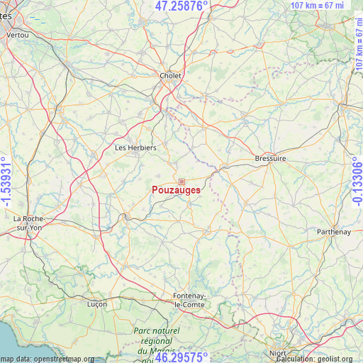
Pouzauges GPS coordinates[2]
46° 46' 45.876" North, 0° 50' 10.284" West
| Map corner | latitude | longitude |
|---|---|---|
| Upper-left | 47.25876°, | -1.53931° |
| Center: | 46.77941°, | -0.83619° |
| Lower-right: | 46.29575°, | -0.13306° |
| Map W x H: | 107.1×107.1 km | = 66.5×66.5mi |
| max Lat: | 51.07786° ⇑57.4% North |
| Pouzauges: | 46.77941° |
| min Lat: | ⇓42.6% South 41.3874° |
| min Long | Pouzauges | max Long |
| -5.08615° | -0.83619° | 9.52242° |
| W 13.2%⇐ | ⇒86.8% E |
Elevation
Elevation of Pouzauges is 170 m = 558 ft, and this is 23.7 m = 78 ft below average elevation for this country.
| Max E: |
2333 m = 7654 ft | 40% |
| Avg. | 193.7 m = 635 ft | |
| Pouzauges | 170 m = 558 ft | |
Min E: |
-1 m = -3 ft | 60% |
See also: France elevation on elevation.city.
Geographical zone
Pouzauges is located in North temperate zone (between Tropic of Cancer and the Arctic Circle). Distance of this North polar circle is 2199.8 km =1366.9 mi to North.| Distance of | km | miles | from Pouzauges |
|---|---|---|---|
| North Pole | 4805.7 | 2986.1 | to North |
| Arctic Circle | 2199.8 | 1366.9 | to North |
| Tropic Cancer | 2595.5 | 1612.8 | to South |
| Equator | 5201.4 | 3232 | to South |


Nearby cities:
15 places around Pouzauges: (largest is in red/bold)
• Chavagnes-les-Redoux
9.5 km =5.9 mi,  221°
221°
• La Flocellière
6.2 km =3.9 mi,  341°
341°
• La Meilleraie-Tillay
4.4 km =2.7 mi,  188°
188°
• La Pommeraie-sur-Sèvre
7.6 km =4.7 mi,  35°
35°
• Le Boupère
7.1 km =4.4 mi,  284°
284°
• Les Châtelliers-Châteaumur
8.5 km =5.3 mi,  8°
8°
• Menomblet
10.9 km =6.8 mi,  119°
119°
• Monsireigne
9.5 km =5.9 mi,  245°
245°
• Montournais
6.9 km =4.3 mi,  127°
127°
• Réaumur
7.1 km =4.4 mi,  159°
159°
• Saint-Amand-sur-Sèvre
10.5 km =6.5 mi,  17°
17°
• Saint-Mars-la-Réorthe
11.4 km =7.1 mi,  323°
323°
• Saint-Mesmin
8 km =5 mi,  78°
78°
• Saint-Michel-Mont-Mercure
6.6 km =4.1 mi,  327°
327°
• Saint-Prouant
9.5 km =5.9 mi,  255°
255°
Sources, notices
• [Note1] Compared only with cities in France existing in our database
• [Src1] Map data: © OpenStreetMap contributors (CC-BY-SA)
• [Src2] Other city data from geonames.org with taken over terms of usage.
• [Src3] Geographical zone / Annual Mean Temperature by Robert A. Rohde @ Wikipedia
