Menat geodata
Menat (Auvergne-Rhône-Alpes) is a populated place; located in France in Europe/Paris (GMT+2) time zone. With population of 645 people, there are 12593 cities with bigger population in this country. Compared to other cities in France, 65% of cities are located further ↑North; 56.5% of cities are located further ←West and 89.5% of cities have lower elevation than Menat. Note1
Administrative division(s):
- Level 1: Auvergne-Rhône-Alpes
- Level 2: Département du Puy-de-Dôme
- Level 3: Arrondissement de Riom
- Level 4: Menat


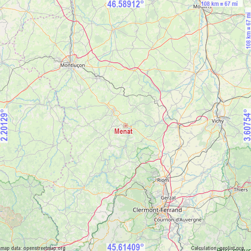
Menat GPS coordinates[2]
46° 6' 13.536" North, 2° 54' 15.912" East
| Map corner | latitude | longitude |
|---|---|---|
| Upper-left | 46.58912°, | 2.20129° |
| Center: | 46.10376°, | 2.90442° |
| Lower-right: | 45.61409°, | 3.60754° |
| Map W x H: | 108.4×108.4 km | = 67.4×67.4mi |
| max Lat: | 51.07786° ⇑65% North |
| Menat: | 46.10376° |
| min Lat: | ⇓35% South 41.3874° |
| min Long | Menat | max Long |
| -5.08615° | 2.90442° | 9.52242° |
| W 56.5%⇐ | ⇒43.5% E |
Elevation
Elevation of Menat is 415 m = 1362 ft, and this is 221.3 m = 726 ft above average elevation for this country.
| Max E: |
2333 m = 7654 ft | 10.5% |
| Menat | 415 m 1362 ft | |
| Avg. | 193.7 m = 635 ft | |
Min E: |
-1 m = -3 ft | 89.5% |
See also: France elevation on elevation.city.
Geographical zone
Menat is located in North temperate zone (between Tropic of Cancer and the Arctic Circle). Distance of this North polar circle is 2274.9 km =1413.6 mi to North.| Distance of | km | miles | from Menat |
|---|---|---|---|
| North Pole | 4880.8 | 3032.8 | to North |
| Arctic Circle | 2274.9 | 1413.6 | to North |
| Tropic Cancer | 2520.3 | 1566 | to South |
| Equator | 5126.3 | 3185.3 | to South |


Nearby cities:
15 places around Menat: (largest is in red/bold)
• Bellenaves
17.3 km =10.7 mi,  51°
51°
• Charbonnières-les-Vieilles
14.1 km =8.8 mi,  149°
149°
• Combronde
19.7 km =12.2 mi,  133°
133°
• Lapeyrouse
13.6 km =8.5 mi,  349°
349°
• Manzat
16.1 km =10 mi,  169°
169°
• Montaigut
11.2 km =7 mi,  318°
318°
• Pionsat
16.3 km =10.1 mi,  272°
272°
• Saint-Bonnet-de-Rochefort
18.6 km =11.6 mi,  75°
75°
• Saint-Georges-de-Mons
19 km =11.8 mi,  195°
195°
• Saint-Gervais-d’Auvergne
10.6 km =6.6 mi,  218°
218°
• Saint-Priest-des-Champs
16.4 km =10.2 mi, 221°
• Saint-Éloy-les-Mines
8.3 km =5.2 mi, 319°
• Servant
4.3 km =2.7 mi,  25°
25°
• Youx
9.3 km =5.8 mi,  299°
299°
• Ébreuil
14.1 km =8.8 mi, 84°
Sources, notices
• [Note1] Compared only with cities in France existing in our database
• [Src1] Map data: © OpenStreetMap contributors (CC-BY-SA)
• [Src2] Other city data from geonames.org with taken over terms of usage.
• [Src3] Geographical zone / Annual Mean Temperature by Robert A. Rohde @ Wikipedia
