Lapeyrouse geodata
Lapeyrouse (Auvergne-Rhône-Alpes) is a populated place; located in France in Europe/Paris (GMT+2) time zone. With population of 584 people, there are 13570 cities with bigger population in this country. Compared to other cities in France, 63.2% of cities are located further ↑North; 56% of cities are located further ←West and 92.7% of cities have lower elevation than Lapeyrouse. Note1
Administrative division(s):
- Level 1: Auvergne-Rhône-Alpes
- Level 2: Département du Puy-de-Dôme
- Level 3: Arrondissement de Riom
- Level 4: Lapeyrouse


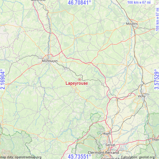
Lapeyrouse GPS coordinates[2]
46° 13' 26.832" North, 2° 52' 19.776" East
| Map corner | latitude | longitude |
|---|---|---|
| Upper-left | 46.70841°, | 2.16904° |
| Center: | 46.22412°, | 2.87216° |
| Lower-right: | 45.73551°, | 3.57529° |
| Map W x H: | 108.2×108.2 km | = 67.2×67.2mi |
| max Lat: | 51.07786° ⇑63.2% North |
| Lapeyrouse: | 46.22412° |
| min Lat: | ⇓36.8% South 41.3874° |
| min Long | Lapeyrouse | max Long |
| -5.08615° | 2.87216° | 9.52242° |
| W 56%⇐ | ⇒44% E |
Elevation
Elevation of Lapeyrouse is 497 m = 1631 ft, and this is 303.3 m = 995 ft above average elevation for this country.
| Max E: |
2333 m = 7654 ft | 7.3% |
| Lapeyrouse | 497 m 1631 ft | |
| Avg. | 193.7 m = 635 ft | |
Min E: |
-1 m = -3 ft | 92.7% |
See also: France elevation on elevation.city.
Geographical zone
Lapeyrouse is located in North temperate zone (between Tropic of Cancer and the Arctic Circle). Distance of this North polar circle is 2261.5 km =1405.2 mi to North.| Distance of | km | miles | from Lapeyrouse |
|---|---|---|---|
| North Pole | 4867.4 | 3024.5 | to North |
| Arctic Circle | 2261.5 | 1405.2 | to North |
| Tropic Cancer | 2533.7 | 1574.4 | to South |
| Equator | 5139.6 | 3193.6 | to South |


Nearby cities:
15 places around Lapeyrouse: (largest is in red/bold)
• Bellenaves
16.2 km =10.1 mi,  99°
99°
• Bézenet
11.8 km =7.3 mi,  349°
349°
• Chamblet
17.8 km =11.1 mi,  312°
312°
• Commentry
12.3 km =7.6 mi, 305°
• Doyet
13.7 km =8.5 mi,  335°
335°
• Larequille
13.5 km =8.4 mi,  283°
283°
• Malicorne
11.1 km =6.9 mi,  321°
321°
• Menat
13.6 km =8.5 mi,  169°
169°
• Montaigut
7 km =4.3 mi,  224°
224°
• Montmarault
12.2 km =7.6 mi,  31°
31°
• Montvicq
11.3 km =7 mi, 339°
• Néris-les-Bains
17.8 km =11.1 mi,  293°
293°
• Saint-Éloy-les-Mines
7.7 km =4.8 mi,  202°
202°
• Servant
10.4 km =6.5 mi,  155°
155°
• Youx
10.5 km =6.5 mi,  212°
212°
Sources, notices
• [Note1] Compared only with cities in France existing in our database
• [Src1] Map data: © OpenStreetMap contributors (CC-BY-SA)
• [Src2] Other city data from geonames.org with taken over terms of usage.
• [Src3] Geographical zone / Annual Mean Temperature by Robert A. Rohde @ Wikipedia
