Montaigut geodata
Montaigut (Auvergne-Rhône-Alpes) is a populated place; located in France in Europe/Paris (GMT+2) time zone. With population of 1,047 people, there are 8486 cities with bigger population in this country. Compared to other cities in France, 63.9% of cities are located further ↑North; 55% of cities are located further ←West and 95.7% of cities have lower elevation than Montaigut. Note1
Administrative division(s):
- Level 1: Auvergne-Rhône-Alpes
- Level 2: Département du Puy-de-Dôme
- Level 3: Arrondissement de Riom
- Level 4: Montaigut


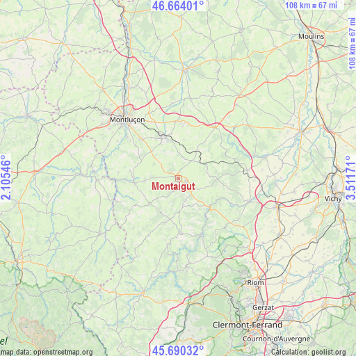
Montaigut GPS coordinates[2]
46° 10' 45.552" North, 2° 48' 30.888" East
| Map corner | latitude | longitude |
|---|---|---|
| Upper-left | 46.66401°, | 2.10546° |
| Center: | 46.17932°, | 2.80858° |
| Lower-right: | 45.69032°, | 3.51171° |
| Map W x H: | 108.3×108.3 km | = 67.3×67.3mi |
| max Lat: | 51.07786° ⇑63.9% North |
| Montaigut: | 46.17932° |
| min Lat: | ⇓36.1% South 41.3874° |
| min Long | Montaigut | max Long |
| -5.08615° | 2.80858° | 9.52242° |
| W 55%⇐ | ⇒45% E |
Elevation
Elevation of Montaigut is 625 m = 2051 ft, and this is 431.3 m = 1415 ft above average elevation for this country.
| Max E: |
2333 m = 7654 ft | 4.3% |
| Montaigut | 625 m 2051 ft | |
| Avg. | 193.7 m = 635 ft | |
Min E: |
-1 m = -3 ft | 95.7% |
See also: France elevation on elevation.city.
Geographical zone
Montaigut is located in North temperate zone (between Tropic of Cancer and the Arctic Circle). Distance of this North polar circle is 2266.5 km =1408.3 mi to North.| Distance of | km | miles | from Montaigut |
|---|---|---|---|
| North Pole | 4872.4 | 3027.6 | to North |
| Arctic Circle | 2266.5 | 1408.3 | to North |
| Tropic Cancer | 2528.7 | 1571.3 | to South |
| Equator | 5134.7 | 3190.6 | to South |


Nearby cities:
15 places around Montaigut: (largest is in red/bold)
• Bézenet
16.9 km =10.5 mi,  9°
9°
• Commentry
13.2 km =8.2 mi,  337°
337°
• Lapeyrouse
7 km =4.3 mi,  44°
44°
• Larequille
11.5 km =7.1 mi,  314°
314°
• Malicorne
13.8 km =8.6 mi,  351°
351°
• Marcillat-en-Combraille
13.6 km =8.5 mi,  264°
264°
• Menat
11.2 km =7 mi,  138°
138°
• Montvicq
15.7 km =9.8 mi,  3°
3°
• Néris-les-Bains
16.6 km =10.3 mi,  316°
316°
• Pionsat
11.8 km =7.3 mi,  228°
228°
• Saint-Gervais-d’Auvergne
16.7 km =10.4 mi,  177°
177°
• Saint-Éloy-les-Mines
2.9 km =1.8 mi, 137°
• Servant
10.3 km =6.4 mi,  115°
115°
• Villebret
16.3 km =10.1 mi, 306°
• Youx
3.9 km =2.4 mi,  190°
190°
Sources, notices
• [Note1] Compared only with cities in France existing in our database
• [Src1] Map data: © OpenStreetMap contributors (CC-BY-SA)
• [Src2] Other city data from geonames.org with taken over terms of usage.
• [Src3] Geographical zone / Annual Mean Temperature by Robert A. Rohde @ Wikipedia
