Yssingeaux geodata
Yssingeaux (Auvergne-Rhône-Alpes) is a seat of a third-order administrative division; located in France in Europe/Paris (GMT+2) time zone. With population of 7,286 people, there are 1341 cities with bigger population in this country. Compared to other cities in France, 78% of cities are located further ↑North; 69% of cities are located further ←West and 98.4% of cities have lower elevation than Yssingeaux. Note1
Administrative division(s):
- Level 1: Auvergne-Rhône-Alpes
- Level 2: Haute-Loire
- Level 3: Yssingeaux
- Level 4: Yssingeaux


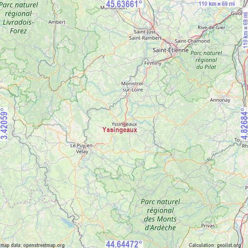
Yssingeaux GPS coordinates[2]
45° 8' 34.152" North, 4° 7' 25.392" East
| Map corner | latitude | longitude |
|---|---|---|
| Upper-left | 45.63661°, | 3.42059° |
| Center: | 45.14282°, | 4.12372° |
| Lower-right: | 44.64472°, | 4.82684° |
| Map W x H: | 110.3×110.3 km | = 68.5×68.5mi |
| max Lat: | 51.07786° ⇑78% North |
| Yssingeaux: | 45.14282° |
| min Lat: | ⇓22% South 41.3874° |
| min Long | Yssingeaux | max Long |
| -5.08615° | 4.12372° | 9.52242° |
| W 69%⇐ | ⇒31% E |
Elevation
Elevation of Yssingeaux is 866 m = 2841 ft, and this is 672.3 m = 2206 ft above average elevation for this country.
| Max E: |
2333 m = 7654 ft | 1.6% |
| Yssingeaux | 866 m 2841 ft | |
| Avg. | 193.7 m = 635 ft | |
Min E: |
-1 m = -3 ft | 98.4% |
See also: France elevation on elevation.city.
Geographical zone
Yssingeaux is located in North temperate zone (between Tropic of Cancer and the Arctic Circle). Distance of this North polar circle is 2381.8 km =1480 mi to North.| Distance of | km | miles | from Yssingeaux |
|---|---|---|---|
| North Pole | 4987.7 | 3099.2 | to North |
| Arctic Circle | 2381.8 | 1480 | to North |
| Tropic Cancer | 2413.5 | 1499.7 | to South |
| Equator | 5019.4 | 3118.9 | to South |


Nearby cities:
15 places around Yssingeaux: (largest is in red/bold)
• Araules
7.1 km =4.4 mi,  146°
146°
• Beaux
5.5 km =3.4 mi,  333°
333°
• Beauzac
13.1 km =8.1 mi,  351°
351°
• Lapte
8.7 km =5.4 mi,  56°
56°
• Les Villettes
11.3 km =7 mi,  24°
24°
• Malrevers
13.3 km =8.3 mi,  248°
248°
• Retournac
9.8 km =6.1 mi,  313°
313°
• Rosières
10.7 km =6.6 mi,  264°
264°
• Saint-Hostien
9.8 km =6.1 mi,  217°
217°
• Saint-Jeures
8.2 km =5.1 mi,  129°
129°
• Saint-Julien-Chapteuil
13 km =8.1 mi,  202°
202°
• Saint-Maurice-de-Lignon
9.1 km =5.7 mi,  7°
7°
• Saint-Pierre-Eynac
12.8 km =8 mi,  213°
213°
• Saint-Étienne-Lardeyrol
12.5 km =7.8 mi,  230°
230°
• Tence
13.5 km =8.4 mi,  103°
103°
Sources, notices
• [Note1] Compared only with cities in France existing in our database
• [Src1] Map data: © OpenStreetMap contributors (CC-BY-SA)
• [Src2] Other city data from geonames.org with taken over terms of usage.
• [Src3] Geographical zone / Annual Mean Temperature by Robert A. Rohde @ Wikipedia
