Bussières geodata
Bussières (Bourgogne-Franche-Comté) is a populated place; located in France in Europe/Paris (GMT+2) time zone. With population of 560 people, there are 14001 cities with bigger population in this country. Compared to other cities in France, 61.8% of cities are located further ↑North; 73.9% of cities are located further ←West and 77.6% of cities have lower elevation than Bussières. Note1
Administrative division(s):
- Level 1: Bourgogne-Franche-Comté
- Level 2: Département de Saône-et-Loire
- Level 3: Arrondissement de Mâcon
- Level 4: Bussières


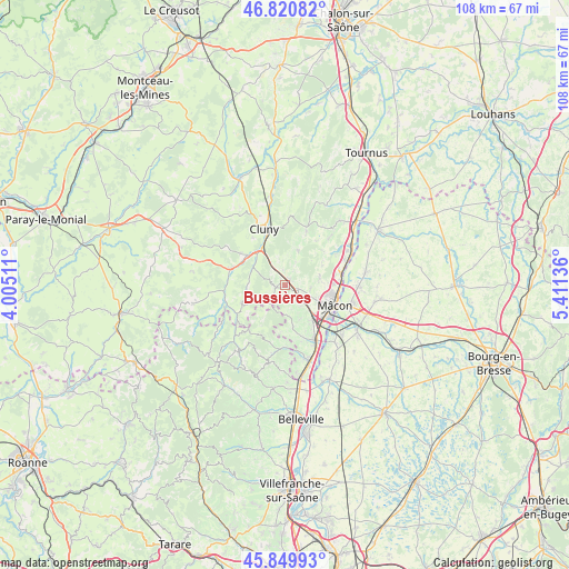
Bussières GPS coordinates[2]
46° 20' 15.108" North, 4° 42' 29.664" East
| Map corner | latitude | longitude |
|---|---|---|
| Upper-left | 46.82082°, | 4.00511° |
| Center: | 46.33753°, | 4.70824° |
| Lower-right: | 45.84993°, | 5.41136° |
| Map W x H: | 108×108 km | = 67.1×67.1mi |
| max Lat: | 51.07786° ⇑61.8% North |
| Bussières: | 46.33753° |
| min Lat: | ⇓38.2% South 41.3874° |
| min Long | Bussières | max Long |
| -5.08615° | 4.70824° | 9.52242° |
| W 73.9%⇐ | ⇒26.1% E |
Elevation
Elevation of Bussières is 269 m = 883 ft, and this is 75.3 m = 247 ft above average elevation for this country.
| Max E: |
2333 m = 7654 ft | 22.4% |
| Bussières | 269 m 883 ft | |
| Avg. | 193.7 m = 635 ft | |
Min E: |
-1 m = -3 ft | 77.6% |
See also: France elevation on elevation.city.
Geographical zone
Bussières is located in North temperate zone (between Tropic of Cancer and the Arctic Circle). Distance of this North polar circle is 2248.9 km =1397.4 mi to North.| Distance of | km | miles | from Bussières |
|---|---|---|---|
| North Pole | 4854.8 | 3016.6 | to North |
| Arctic Circle | 2248.9 | 1397.4 | to North |
| Tropic Cancer | 2546.3 | 1582.2 | to South |
| Equator | 5152.3 | 3201.5 | to South |


Nearby cities:
15 places around Bussières: (largest is in red/bold)
• Berzé-la-Ville
2.9 km =1.8 mi,  353°
353°
• Chaintré
9.5 km =5.9 mi,  155°
155°
• Charnay-lès-Mâcon
6.8 km =4.2 mi,  119°
119°
• Davayé
4.6 km =2.9 mi,  144°
144°
• Hurigny
6.9 km =4.3 mi,  80°
80°
• Igé
7.2 km =4.5 mi,  20°
20°
• La Roche-Vineuse
1.3 km =0.8 mi,  47°
47°
• Leynes
7.7 km =4.8 mi,  168°
168°
• Mâcon
9.6 km =6 mi,  105°
105°
• Pierreclos
1.7 km =1.1 mi,  260°
260°
• Prissé
3.3 km =2.1 mi, 122°
• Sancé
9.4 km =5.8 mi,  88°
88°
• Tramayes
8.9 km =5.5 mi,  245°
245°
• Verzé
4.9 km =3 mi,  25°
25°
• Vinzelles
8.5 km =5.3 mi,  147°
147°
Sources, notices
• [Note1] Compared only with cities in France existing in our database
• [Src1] Map data: © OpenStreetMap contributors (CC-BY-SA)
• [Src2] Other city data from geonames.org with taken over terms of usage.
• [Src3] Geographical zone / Annual Mean Temperature by Robert A. Rohde @ Wikipedia
