Martizay geodata
Martizay (Centre) is a populated place; located in France in Europe/Paris (GMT+2) time zone. With population of 1,062 people, there are 8387 cities with bigger population in this country. Compared to other cities in France, 57.1% of cities are located further ↑North; 68.3% of cities are located further →East and 68.3% of cities have higher elevation than Martizay. Note1
Administrative division(s):
- Level 1: Centre
- Level 2: Département de l'Indre
- Level 3: Le Blanc
- Level 4: Martizay


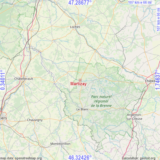
Martizay GPS coordinates[2]
46° 48' 27.612" North, 1° 2' 35.664" East
| Map corner | latitude | longitude |
|---|---|---|
| Upper-left | 47.28677°, | 0.34011° |
| Center: | 46.80767°, | 1.04324° |
| Lower-right: | 46.32426°, | 1.74637° |
| Map W x H: | 107×107 km | = 66.5×66.5mi |
| max Lat: | 51.07786° ⇑57.1% North |
| Martizay: | 46.80767° |
| min Lat: | ⇓42.9% South 41.3874° |
| min Long | Martizay | max Long |
| -5.08615° | 1.04324° | 9.52242° |
| W 31.7%⇐ | ⇒68.3% E |
Elevation
Elevation of Martizay is 82 m = 269 ft, and this is 111.7 m = 366 ft below average elevation for this country.
| Max E: |
2333 m = 7654 ft | 68.3% |
| Avg. | 193.7 m = 635 ft | |
| Martizay | 82 m = 269 ft | |
Min E: |
-1 m = -3 ft | 31.7% |
See also: France elevation on elevation.city.
Geographical zone
Martizay is located in North temperate zone (between Tropic of Cancer and the Arctic Circle). Distance of this North polar circle is 2196.6 km =1364.9 mi to North.| Distance of | km | miles | from Martizay |
|---|---|---|---|
| North Pole | 4802.5 | 2984.1 | to North |
| Arctic Circle | 2196.6 | 1364.9 | to North |
| Tropic Cancer | 2598.6 | 1614.7 | to South |
| Equator | 5204.5 | 3233.9 | to South |


Nearby cities:
15 places around Martizay: (largest is in red/bold)
• Azay-le-Ferron
5.3 km =3.3 mi,  23°
23°
• Bossay-sur-Claise
6.8 km =4.2 mi,  293°
293°
• Charnizay
12.5 km =7.8 mi,  339°
339°
• Clion
20.6 km =12.8 mi,  44°
44°
• La Roche-Posay
17.7 km =11 mi,  262°
262°
• Le Blanc
19.4 km =12.1 mi,  175°
175°
• Mézières-en-Brenne
12.9 km =8 mi,  83°
83°
• Pouligny-Saint-Pierre
14.1 km =8.8 mi, 181°
• Preuilly-sur-Claise
10.1 km =6.3 mi,  300°
300°
• Rosnay
17.6 km =10.9 mi,  132°
132°
• Saint-Flovier
17.9 km =11.1 mi,  356°
356°
• Tournon-Saint-Martin
10.6 km =6.6 mi,  219°
219°
• Tournon-Saint-Pierre
10.3 km =6.4 mi, 222°
• Vicq-sur-Gartempe
16.8 km =10.4 mi,  235°
235°
• Yzeures-sur-Creuse
13.3 km =8.3 mi, 259°
Sources, notices
• [Note1] Compared only with cities in France existing in our database
• [Src1] Map data: © OpenStreetMap contributors (CC-BY-SA)
• [Src2] Other city data from geonames.org with taken over terms of usage.
• [Src3] Geographical zone / Annual Mean Temperature by Robert A. Rohde @ Wikipedia
