Charnizay geodata
Charnizay (Centre) is a populated place; located in France in Europe/Paris (GMT+2) time zone. With population of 549 people, there are 14229 cities with bigger population in this country. Compared to other cities in France, 56.1% of cities are located further ↑North; 68.9% of cities are located further →East and 54.4% of cities have higher elevation than Charnizay. Note1
Administrative division(s):
- Level 1: Centre
- Level 2: Département d'Indre-et-Loire
- Level 3: Arrondissement de Loches
- Level 4: Charnizay


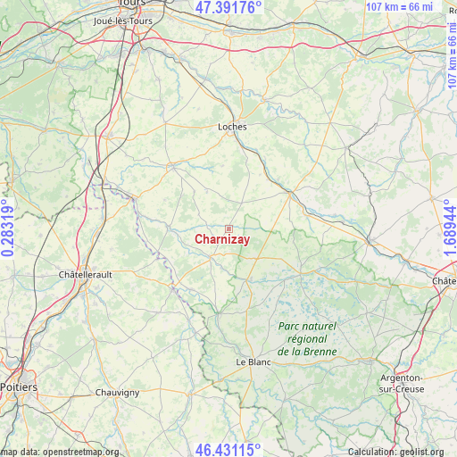
Charnizay GPS coordinates[2]
46° 54' 48.996" North, 0° 59' 10.716" East
| Map corner | latitude | longitude |
|---|---|---|
| Upper-left | 47.39176°, | 0.28319° |
| Center: | 46.91361°, | 0.98631° |
| Lower-right: | 46.43115°, | 1.68944° |
| Map W x H: | 106.8×106.8 km | = 66.4×66.4mi |
| max Lat: | 51.07786° ⇑56.1% North |
| Charnizay: | 46.91361° |
| min Lat: | ⇓43.9% South 41.3874° |
| min Long | Charnizay | max Long |
| -5.08615° | 0.98631° | 9.52242° |
| W 31.1%⇐ | ⇒68.9% E |
Elevation
Elevation of Charnizay is 118 m = 387 ft, and this is 75.7 m = 248 ft below average elevation for this country.
| Max E: |
2333 m = 7654 ft | 54.4% |
| Avg. | 193.7 m = 635 ft | |
| Charnizay | 118 m = 387 ft | |
Min E: |
-1 m = -3 ft | 45.6% |
See also: France elevation on elevation.city.
Geographical zone
Charnizay is located in North temperate zone (between Tropic of Cancer and the Arctic Circle). Distance of this North polar circle is 2184.9 km =1357.6 mi to North.| Distance of | km | miles | from Charnizay |
|---|---|---|---|
| North Pole | 4790.8 | 2976.9 | to North |
| Arctic Circle | 2184.9 | 1357.6 | to North |
| Tropic Cancer | 2610.4 | 1622 | to South |
| Equator | 5216.3 | 3241.3 | to South |


Nearby cities:
15 places around Charnizay: (largest is in red/bold)
• Azay-le-Ferron
9.5 km =5.9 mi,  137°
137°
• Barrou
17.3 km =10.7 mi,  252°
252°
• Betz-le-Château
10.1 km =6.3 mi,  329°
329°
• Bossay-sur-Claise
9.3 km =5.8 mi,  191°
191°
• Bridoré
14.7 km =9.1 mi,  29°
29°
• Châtillon-sur-Indre
16.3 km =10.1 mi,  59°
59°
• Fléré-la-Rivière
15 km =9.3 mi,  37°
37°
• Le Grand-Pressigny
13.9 km =8.6 mi,  273°
273°
• Lésigny
18.2 km =11.3 mi, 246°
• Martizay
12.5 km =7.8 mi,  159°
159°
• Preuilly-sur-Claise
7.9 km =4.9 mi,  213°
213°
• Saint-Flovier
6.8 km =4.2 mi, 26°
• Saint-Hippolyte
18.3 km =11.4 mi, 28°
• Verneuil-sur-Indre
16.3 km =10.1 mi,  14°
14°
• Yzeures-sur-Creuse
16.6 km =10.3 mi, 211°
Sources, notices
• [Note1] Compared only with cities in France existing in our database
• [Src1] Map data: © OpenStreetMap contributors (CC-BY-SA)
• [Src2] Other city data from geonames.org with taken over terms of usage.
• [Src3] Geographical zone / Annual Mean Temperature by Robert A. Rohde @ Wikipedia
