Mars-la-Tour geodata
Mars-la-Tour (Grand Est) is a populated place; located in France in Europe/Paris (GMT+2) time zone. With population of 873 people, there are 9873 cities with bigger population in this country. Compared to other cities in France, 82.1% of cities are located further ↓South; 85.8% of cities are located further ←West and 73.2% of cities have lower elevation than Mars-la-Tour. Note1
Administrative division(s):
- Level 1: Grand Est
- Level 2: Meurthe-et-Moselle
- Level 3: Arrondissement de Briey
- Level 4: Mars-la-Tour


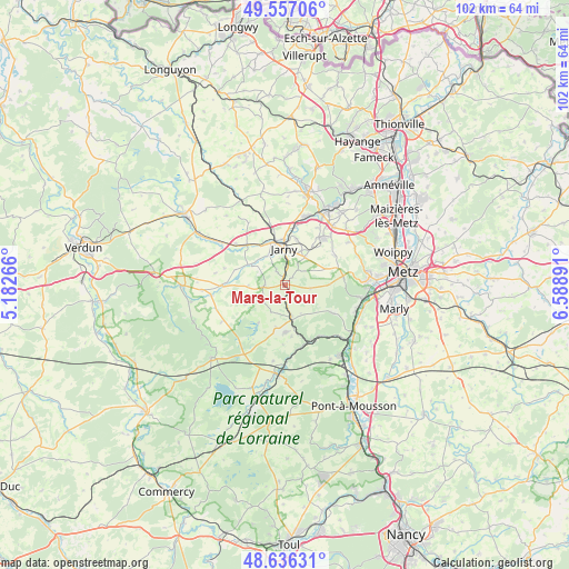
Mars-la-Tour GPS coordinates[2]
49° 5' 55.752" North, 5° 53' 8.808" East
| Map corner | latitude | longitude |
|---|---|---|
| Upper-left | 49.55706°, | 5.18266° |
| Center: | 49.09882°, | 5.88578° |
| Lower-right: | 48.63631°, | 6.58891° |
| Map W x H: | 102.4×102.4 km | = 63.6×63.6mi |
| max Lat: | 51.07786° ⇑17.9% North |
| Mars-la-Tour: | 49.09882° |
| min Lat: | ⇓82.1% South 41.3874° |
| min Long | Mars-la-Tour | max Long |
| -5.08615° | 5.88578° | 9.52242° |
| W 85.8%⇐ | ⇒14.2% E |
Elevation
Elevation of Mars-la-Tour is 237 m = 778 ft, and this is 43.3 m = 142 ft above average elevation for this country.
| Max E: |
2333 m = 7654 ft | 26.8% |
| Mars-la-Tour | 237 m 778 ft | |
| Avg. | 193.7 m = 635 ft | |
Min E: |
-1 m = -3 ft | 73.2% |
See also: France elevation on elevation.city.
Geographical zone
Mars-la-Tour is located in North temperate zone (between Tropic of Cancer and the Arctic Circle). Distance of this North polar circle is 1941.9 km =1206.6 mi to North.| Distance of | km | miles | from Mars-la-Tour |
|---|---|---|---|
| North Pole | 4547.8 | 2825.9 | to North |
| Arctic Circle | 1941.9 | 1206.6 | to North |
| Tropic Cancer | 2853.4 | 1773 | to South |
| Equator | 5459.3 | 3392.3 | to South |


Nearby cities:
15 places around Mars-la-Tour: (largest is in red/bold)
• Ancy-sur-Moselle
13.4 km =8.3 mi,  110°
110°
• Batilly
10.3 km =6.4 mi,  35°
35°
• Conflans-en-Jarnisy
7.9 km =4.9 mi,  343°
343°
• Doncourt-lès-Conflans
6 km =3.7 mi, 35°
• Giraumont
8.3 km =5.2 mi,  14°
14°
• Gorze
9.8 km =6.1 mi,  121°
121°
• Gravelotte
10.5 km =6.5 mi,  83°
83°
• Hatrize
10.5 km =6.5 mi, 9°
• Jarny
6.7 km =4.2 mi,  354°
354°
• Labry
8.2 km =5.1 mi,  357°
357°
• Moineville
12.6 km =7.8 mi,  19°
19°
• Onville
11 km =6.8 mi,  146°
146°
• Sainte-Marie-aux-Chênes
13.4 km =8.3 mi, 38°
• Valleroy
12.9 km =8 mi, 16°
• Vernéville
10.1 km =6.3 mi,  58°
58°
Sources, notices
• [Note1] Compared only with cities in France existing in our database
• [Src1] Map data: © OpenStreetMap contributors (CC-BY-SA)
• [Src2] Other city data from geonames.org with taken over terms of usage.
• [Src3] Geographical zone / Annual Mean Temperature by Robert A. Rohde @ Wikipedia
