Malicorne-sur-Sarthe geodata
Malicorne-sur-Sarthe (Pays de la Loire) is a populated place; located in France in Europe/Paris (GMT+2) time zone. With population of 1,920 people, there are 4990 cities with bigger population in this country. Compared to other cities in France, 55.9% of cities are located further ↓South; 78.7% of cities are located further →East and 87.1% of cities have higher elevation than Malicorne-sur-Sarthe. Note1
Administrative division(s):
- Level 1: Pays de la Loire
- Level 2: Sarthe
- Level 3: Arrondissement de La Flèche
- Level 4: Malicorne-sur-Sarthe


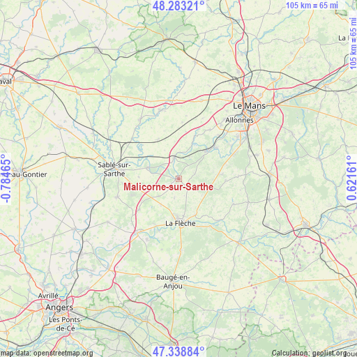
Malicorne-sur-Sarthe GPS coordinates[2]
47° 48' 47.412" North, 0° 4' 53.472" West
| Map corner | latitude | longitude |
|---|---|---|
| Upper-left | 48.28321°, | -0.78465° |
| Center: | 47.81317°, | -0.08152° |
| Lower-right: | 47.33884°, | 0.62161° |
| Map W x H: | 105×105 km | = 65.2×65.2mi |
| max Lat: | 51.07786° ⇑44.1% North |
| Malicorne-sur-Sarthe: | 47.81317° |
| min Lat: | ⇓55.9% South 41.3874° |
| min Long | Malicorne-sur-S | max Long |
| -5.08615° | -0.08152° | 9.52242° |
| W 21.3%⇐ | ⇒78.7% E |
Elevation
Elevation of Malicorne-sur-Sarthe is 37 m = 121 ft, and this is 156.7 m = 514 ft below average elevation for this country.
| Max E: |
2333 m = 7654 ft | 87.1% |
| Avg. | 193.7 m = 635 ft | |
| Malicorne-sur-Sarthe | 37 m = 121 ft | |
Min E: |
-1 m = -3 ft | 12.9% |
See also: France elevation on elevation.city.
Geographical zone
Malicorne-sur-Sarthe is located in North temperate zone (between Tropic of Cancer and the Arctic Circle). Distance of this North polar circle is 2084.8 km =1295.4 mi to North.| Distance of | km | miles | from Malicorne-sur-Sarthe |
|---|---|---|---|
| North Pole | 4690.7 | 2914.7 | to North |
| Arctic Circle | 2084.8 | 1295.4 | to North |
| Tropic Cancer | 2710.4 | 1684.2 | to South |
| Equator | 5316.3 | 3303.4 | to South |


Nearby cities:
15 places around Malicorne-sur-Sarthe: (largest is in red/bold)
• Avoise
11.2 km =7 mi,  302°
302°
• Clermont-Créans
11.7 km =7.3 mi,  154°
154°
• Crosmières
9.2 km =5.7 mi,  214°
214°
• Cérans-Foulletourte
11.9 km =7.4 mi,  82°
82°
• Fercé-sur-Sarthe
10.5 km =6.5 mi,  20°
20°
• La Flèche
12.8 km =8 mi,  177°
177°
• La Suze-sur-Sarthe
11.5 km =7.1 mi,  43°
43°
• Louailles
12.9 km =8 mi,  259°
259°
• Mézeray
5 km =3.1 mi,  72°
72°
• Noyen-sur-Sarthe
6.7 km =4.2 mi,  348°
348°
• Parcé-sur-Sarthe
9.5 km =5.9 mi,  290°
290°
• Saint-Jean-de-la-Motte
12.9 km =8 mi,  126°
126°
• Saint-Jean-du-Bois
7.3 km =4.5 mi,  25°
25°
• Villaines-sous-Malicorne
5.7 km =3.5 mi,  193°
193°
• Vion
11.8 km =7.3 mi,  273°
273°
Sources, notices
• [Note1] Compared only with cities in France existing in our database
• [Src1] Map data: © OpenStreetMap contributors (CC-BY-SA)
• [Src2] Other city data from geonames.org with taken over terms of usage.
• [Src3] Geographical zone / Annual Mean Temperature by Robert A. Rohde @ Wikipedia
